You are here: Home > Network List > UW - Pacific Northwest Regional Seismic Network Stations List
> Station LEBA Lebam, WA, USA > Earthquake Result Viewer
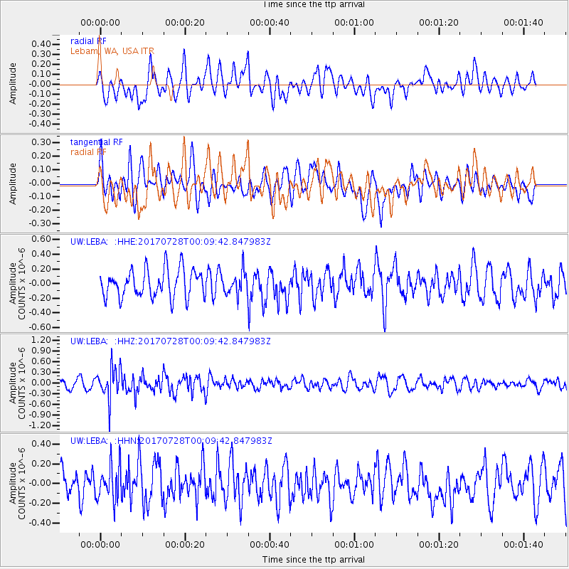
LEBA Lebam, WA, USA - Earthquake Result Viewer
*The percent match for this event was below the threshold and hence no stack was calculated.
| Earthquake location: |
Southeast Of Honshu, Japan |
| Earthquake latitude/longitude: |
29.3/143.0 |
| Earthquake time(UTC): |
2017/07/27 (208) 23:58:52 GMT |
| Earthquake Depth: |
10 km |
| Earthquake Magnitude: |
5.3 Mww |
| Earthquake Catalog/Contributor: |
NEIC PDE/us |
|
| Network: |
UW Pacific Northwest Regional Seismic Network |
| Station: |
LEBA Lebam, WA, USA |
| Lat/Lon: |
46.55 N/123.56 W |
| Elevation: |
73 m |
|
| Distance: |
71.6 deg |
| Az: |
46.553 deg |
| Baz: |
293.225 deg |
| Ray Param: |
$rayparam |
*The percent match for this event was below the threshold and hence was not used in the summary stack. |
|
| Radial Match: |
50.691967 % |
| Radial Bump: |
400 |
| Transverse Match: |
55.14848 % |
| Transverse Bump: |
400 |
| SOD ConfigId: |
13570011 |
| Insert Time: |
2019-04-28 11:57:48.237 +0000 |
| GWidth: |
2.5 |
| Max Bumps: |
400 |
| Tol: |
0.001 |
|
Signal To Noise
| Channel | StoN | STA | LTA |
| UW:LEBA: :HHZ:20170728T00:09:42.847983Z | 4.355086 | 4.4495522E-7 | 1.02169096E-7 |
| UW:LEBA: :HHN:20170728T00:09:42.847983Z | 1.1878073 | 1.8364696E-7 | 1.5461006E-7 |
| UW:LEBA: :HHE:20170728T00:09:42.847983Z | 0.86778104 | 1.6469151E-7 | 1.8978464E-7 |
| Arrivals |
| Ps | |
| PpPs | |
| PsPs/PpSs | |


