You are here: Home > Network List > TA - USArray Transportable Network (new EarthScope stations) Stations List
> Station I25A Rochford, SD, USA > Earthquake Result Viewer
I25A Rochford, SD, USA - Earthquake Result Viewer
| Earthquake location: |
Kuril Islands |
| Earthquake latitude/longitude: |
48.3/154.2 |
| Earthquake time(UTC): |
2009/09/10 (253) 02:46:50 GMT |
| Earthquake Depth: |
36 km |
| Earthquake Magnitude: |
6.0 MB, 5.5 MS, 6.0 MW, 5.8 MW |
| Earthquake Catalog/Contributor: |
WHDF/NEIC |
|
| Network: |
TA USArray Transportable Network (new EarthScope stations) |
| Station: |
I25A Rochford, SD, USA |
| Lat/Lon: |
44.02 N/103.73 W |
| Elevation: |
1856 m |
|
| Distance: |
65.5 deg |
| Az: |
50.837 deg |
| Baz: |
314.161 deg |
| Ray Param: |
0.058178414 |
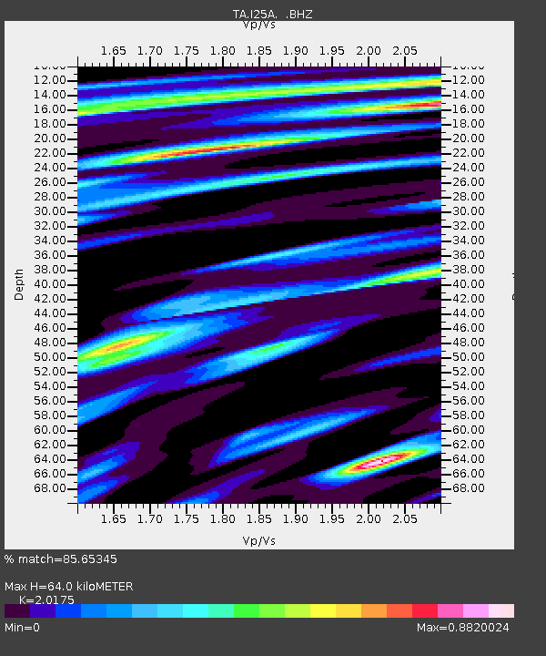
| Estimated Moho Depth: |
64.0 km |
| Estimated Crust Vp/Vs: |
2.02 |
| Assumed Crust Vp: |
6.242 km/s |
| Estimated Crust Vs: |
3.094 km/s |
| Estimated Crust Poisson's Ratio: |
0.34 |
|
| Radial Match: |
85.65345 % |
| Radial Bump: |
400 |
| Transverse Match: |
72.22871 % |
| Transverse Bump: |
400 |
| SOD ConfigId: |
2622 |
| Insert Time: |
2010-03-06 02:23:41.986 +0000 |
| GWidth: |
2.5 |
| Max Bumps: |
400 |
| Tol: |
0.001 |
|

Signal To Noise
| Channel | StoN | STA | LTA |
| TA:I25A: :BHZ:20090910T02:56:59.073999Z | 4.916403 | 5.927777E-7 | 1.2057143E-7 |
| TA:I25A: :BHN:20090910T02:56:59.073999Z | 1.628946 | 1.2170787E-7 | 7.471572E-8 |
| TA:I25A: :BHE:20090910T02:56:59.073999Z | 3.5363507 | 2.2233222E-7 | 6.287052E-8 |
| Arrivals |
| Ps | 11 SECOND |
| PpPs | 30 SECOND |
| PsPs/PpSs | 41 SECOND |


