You are here: Home > Network List > TA - USArray Transportable Network (new EarthScope stations) Stations List
> Station I25A Rochford, SD, USA > Earthquake Result Viewer
I25A Rochford, SD, USA - Earthquake Result Viewer
| Earthquake location: |
Samoa Islands Region |
| Earthquake latitude/longitude: |
-15.5/-172.1 |
| Earthquake time(UTC): |
2009/09/29 (272) 17:48:10 GMT |
| Earthquake Depth: |
18 km |
| Earthquake Magnitude: |
7.1 MB, 8.1 MS, 8.1 MW, 8.0 MW |
| Earthquake Catalog/Contributor: |
WHDF/NEIC |
|
| Network: |
TA USArray Transportable Network (new EarthScope stations) |
| Station: |
I25A Rochford, SD, USA |
| Lat/Lon: |
44.02 N/103.73 W |
| Elevation: |
1856 m |
|
| Distance: |
85.8 deg |
| Az: |
42.251 deg |
| Baz: |
243.972 deg |
| Ray Param: |
0.0444688 |
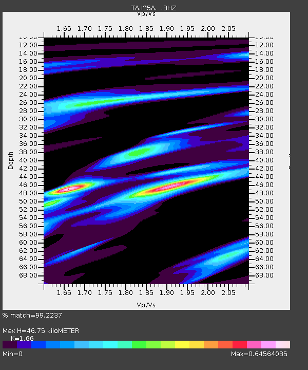
| Estimated Moho Depth: |
46.75 km |
| Estimated Crust Vp/Vs: |
1.66 |
| Assumed Crust Vp: |
6.242 km/s |
| Estimated Crust Vs: |
3.76 km/s |
| Estimated Crust Poisson's Ratio: |
0.22 |
|
| Radial Match: |
99.2237 % |
| Radial Bump: |
263 |
| Transverse Match: |
90.88252 % |
| Transverse Bump: |
400 |
| SOD ConfigId: |
2622 |
| Insert Time: |
2010-03-06 02:23:44.840 +0000 |
| GWidth: |
2.5 |
| Max Bumps: |
400 |
| Tol: |
0.001 |
|

Signal To Noise
| Channel | StoN | STA | LTA |
| TA:I25A: :BHZ:20090929T18:00:17.849009Z | 11.514974 | 2.4906676E-6 | 2.1629816E-7 |
| TA:I25A: :BHN:20090929T18:00:17.849009Z | 2.6761024 | 3.774038E-7 | 1.4102741E-7 |
| TA:I25A: :BHE:20090929T18:00:17.849009Z | 8.841927 | 9.725824E-7 | 1.0999665E-7 |
| Arrivals |
| Ps | 5.1 SECOND |
| PpPs | 19 SECOND |
| PsPs/PpSs | 25 SECOND |


