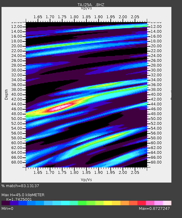
I25A Rochford, SD, USA - Earthquake Result Viewer

Earthquake location: Rat Islands, Aleutian Islands
Earthquake latitude/longitude: 50.4/177.0
Earthquake time(UTC): 2009/07/06 (187) 14:53:12 GMT
Earthquake Depth: 22 km
Earthquake Magnitude: 6.0 MB, 5.8 MS, 6.1 MW, 6.0 MW
Earthquake Catalog/Contributor: WHDF/NEIC
Network: TA USArray Transportable Network (new EarthScope stations)
Station: I25A Rochford, SD, USA
Lat/Lon: 44.02 N/103.73 W
Elevation: 1856 m
Distance: 51.8 deg
Az: 64.399 deg
Baz: 306.927 deg
Ray Param: 0.06713608
Estimated Moho Depth: 45.0 km
Estimated Crust Vp/Vs: 1.74
Assumed Crust Vp: 6.242 km/s
Estimated Crust Vs: 3.582 km/s
Estimated Crust Poisson's Ratio: 0.25
Radial Match: 83.13137 %
Radial Bump: 400
Transverse Match: 68.0962 %
Transverse Bump: 400
SOD ConfigId: 2648
Insert Time: 2010-03-06 02:23:52.421 +0000
GWidth: 2.5
Max Bumps: 400
Tol: 0.001

Signal To Noise

ChannelStoNSTALTA
TA:I25A: :BHZ:20090706T15:01:47.523997Z5.3001881.0401639E-61.9625037E-7
TA:I25A: :BHN:20090706T15:01:47.523997Z2.60720162.5217093E-79.672092E-8
TA:I25A: :BHE:20090706T15:01:47.523997Z2.08985424.6407632E-72.2206159E-7
Arrivals
Ps5.6 SECOND
PpPs19 SECOND
PsPs/PpSs24 SECOND