You are here: Home > Network List > TA - USArray Transportable Network (new EarthScope stations) Stations List
> Station H27A Howes, SD, USA > Earthquake Result Viewer
H27A Howes, SD, USA - Earthquake Result Viewer
| Earthquake location: |
Norwegian Sea |
| Earthquake latitude/longitude: |
72.2/0.9 |
| Earthquake time(UTC): |
2009/08/20 (232) 06:35:04 GMT |
| Earthquake Depth: |
6.0 km |
| Earthquake Magnitude: |
5.9 MB, 5.7 MS, 6.0 MW, 6.0 MW |
| Earthquake Catalog/Contributor: |
WHDF/NEIC |
|
| Network: |
TA USArray Transportable Network (new EarthScope stations) |
| Station: |
H27A Howes, SD, USA |
| Lat/Lon: |
44.63 N/102.08 W |
| Elevation: |
748 m |
|
| Distance: |
51.9 deg |
| Az: |
297.907 deg |
| Baz: |
22.376 deg |
| Ray Param: |
0.0671058 |
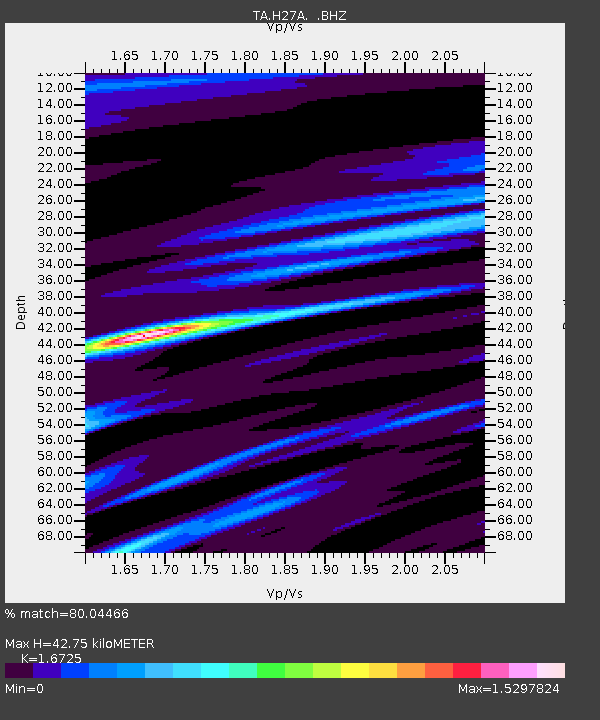
| Estimated Moho Depth: |
42.75 km |
| Estimated Crust Vp/Vs: |
1.67 |
| Assumed Crust Vp: |
6.242 km/s |
| Estimated Crust Vs: |
3.732 km/s |
| Estimated Crust Poisson's Ratio: |
0.22 |
|
| Radial Match: |
80.04466 % |
| Radial Bump: |
400 |
| Transverse Match: |
71.161995 % |
| Transverse Bump: |
400 |
| SOD ConfigId: |
2622 |
| Insert Time: |
2010-03-06 02:24:14.373 +0000 |
| GWidth: |
2.5 |
| Max Bumps: |
400 |
| Tol: |
0.001 |
|

Signal To Noise
| Channel | StoN | STA | LTA |
| TA:H27A: :BHZ:20090820T06:43:42.875007Z | 15.739545 | 1.3134744E-6 | 8.34506E-8 |
| TA:H27A: :BHN:20090820T06:43:42.875007Z | 3.343249 | 5.8217245E-7 | 1.7413373E-7 |
| TA:H27A: :BHE:20090820T06:43:42.875007Z | 1.4200158 | 2.7344504E-7 | 1.9256478E-7 |
| Arrivals |
| Ps | 4.9 SECOND |
| PpPs | 17 SECOND |
| PsPs/PpSs | 22 SECOND |


