You are here: Home > Network List > TA - USArray Transportable Network (new EarthScope stations) Stations List
> Station H27A Howes, SD, USA > Earthquake Result Viewer
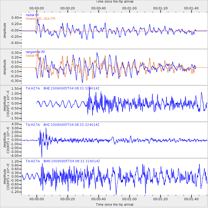
H27A Howes, SD, USA - Earthquake Result Viewer
*The percent match for this event was below the threshold and hence no stack was calculated.
| Earthquake location: |
Southern Peru |
| Earthquake latitude/longitude: |
-15.1/-70.2 |
| Earthquake time(UTC): |
2009/09/05 (248) 03:58:39 GMT |
| Earthquake Depth: |
210 km |
| Earthquake Magnitude: |
5.8 MW, 5.2 MB, 5.8 MW |
| Earthquake Catalog/Contributor: |
WHDF/NEIC |
|
| Network: |
TA USArray Transportable Network (new EarthScope stations) |
| Station: |
H27A Howes, SD, USA |
| Lat/Lon: |
44.63 N/102.08 W |
| Elevation: |
748 m |
|
| Distance: |
66.1 deg |
| Az: |
335.688 deg |
| Baz: |
146.156 deg |
| Ray Param: |
$rayparam |
*The percent match for this event was below the threshold and hence was not used in the summary stack. |
|
| Radial Match: |
73.8893 % |
| Radial Bump: |
400 |
| Transverse Match: |
68.62694 % |
| Transverse Bump: |
400 |
| SOD ConfigId: |
2622 |
| Insert Time: |
2010-03-06 02:24:36.203 +0000 |
| GWidth: |
2.5 |
| Max Bumps: |
400 |
| Tol: |
0.001 |
|
Signal To Noise
| Channel | StoN | STA | LTA |
| TA:H27A: :BHZ:20090905T04:08:33.324014Z | 11.924257 | 1.252517E-6 | 1.0503941E-7 |
| TA:H27A: :BHN:20090905T04:08:33.324014Z | 2.4906347 | 3.9697366E-7 | 1.5938653E-7 |
| TA:H27A: :BHE:20090905T04:08:33.324014Z | 2.248725 | 4.808269E-7 | 2.13822E-7 |
| Arrivals |
| Ps | |
| PpPs | |
| PsPs/PpSs | |


