You are here: Home > Network List > CI - Caltech Regional Seismic Network Stations List
> Station CHF Chilao Flat Rngr Sta, Altadena, CA, USA > Earthquake Result Viewer
CHF Chilao Flat Rngr Sta, Altadena, CA, USA - Earthquake Result Viewer
| Earthquake location: |
Southern Alaska |
| Earthquake latitude/longitude: |
59.0/-155.1 |
| Earthquake time(UTC): |
2001/07/28 (209) 07:32:43 GMT |
| Earthquake Depth: |
131 km |
| Earthquake Magnitude: |
5.7 MB, 5.7 MS, 6.6 MW, 6.2 ME |
| Earthquake Catalog/Contributor: |
WHDF/NEIC |
|
| Network: |
CI Caltech Regional Seismic Network |
| Station: |
CHF Chilao Flat Rngr Sta, Altadena, CA, USA |
| Lat/Lon: |
34.33 N/118.03 W |
| Elevation: |
1594 m |
|
| Distance: |
34.7 deg |
| Az: |
118.82 deg |
| Baz: |
326.798 deg |
| Ray Param: |
0.07715898 |
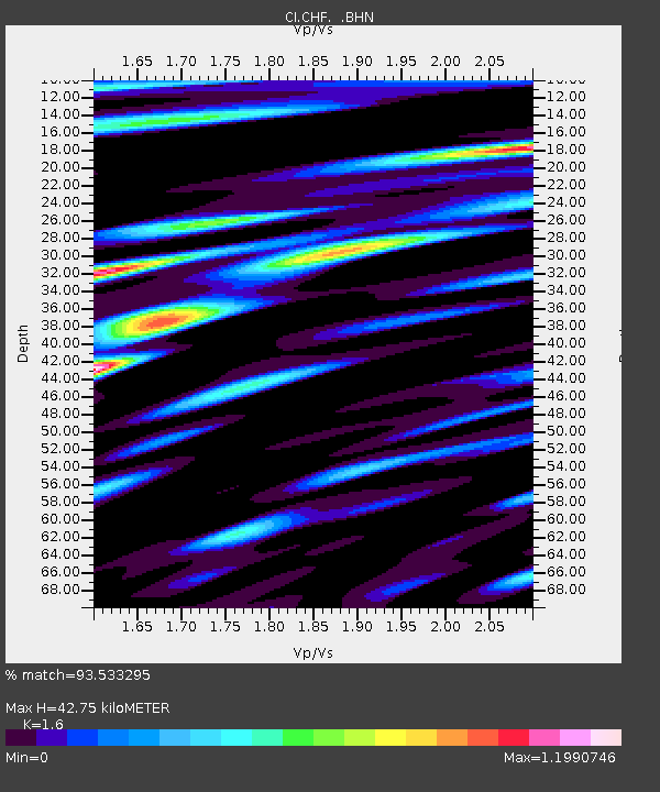
| Estimated Moho Depth: |
42.75 km |
| Estimated Crust Vp/Vs: |
1.60 |
| Assumed Crust Vp: |
6.1 km/s |
| Estimated Crust Vs: |
3.812 km/s |
| Estimated Crust Poisson's Ratio: |
0.18 |
|
| Radial Match: |
93.533295 % |
| Radial Bump: |
400 |
| Transverse Match: |
87.27068 % |
| Transverse Bump: |
400 |
| SOD ConfigId: |
3787 |
| Insert Time: |
2010-02-26 01:22:17.196 +0000 |
| GWidth: |
2.5 |
| Max Bumps: |
400 |
| Tol: |
0.001 |
|
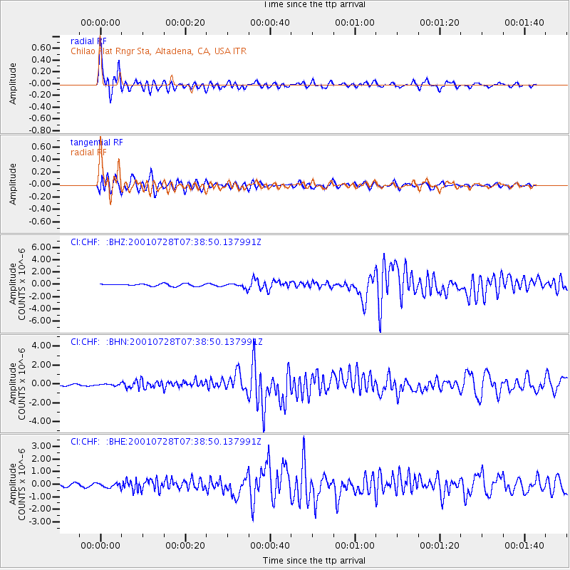
Signal To Noise
| Channel | StoN | STA | LTA |
| CI:CHF: :BHN:20010728T07:38:50.137991Z | 0.7173807 | 9.1066184E-8 | 1.2694262E-7 |
| CI:CHF: :BHE:20010728T07:38:50.137991Z | 1.3174157 | 1.8371001E-7 | 1.3944727E-7 |
| CI:CHF: :BHZ:20010728T07:38:50.137991Z | 2.163746 | 3.9944922E-7 | 1.8461003E-7 |
| Arrivals |
| Ps | 4.5 SECOND |
| PpPs | 17 SECOND |
| PsPs/PpSs | 21 SECOND |


