You are here: Home > Network List > TA - USArray Transportable Network (new EarthScope stations) Stations List
> Station G28A Parade, SD, USA > Earthquake Result Viewer
G28A Parade, SD, USA - Earthquake Result Viewer
| Earthquake location: |
Near S. Coast Of Honshu, Japan |
| Earthquake latitude/longitude: |
33.2/137.9 |
| Earthquake time(UTC): |
2009/08/09 (221) 10:55:55 GMT |
| Earthquake Depth: |
297 km |
| Earthquake Magnitude: |
6.5 MB, 7.1 MW, 7.1 MW |
| Earthquake Catalog/Contributor: |
WHDF/NEIC |
|
| Network: |
TA USArray Transportable Network (new EarthScope stations) |
| Station: |
G28A Parade, SD, USA |
| Lat/Lon: |
45.07 N/100.92 W |
| Elevation: |
709 m |
|
| Distance: |
85.6 deg |
| Az: |
37.462 deg |
| Baz: |
313.945 deg |
| Ray Param: |
0.043917418 |
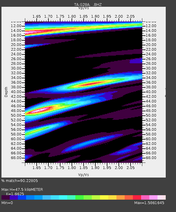
| Estimated Moho Depth: |
47.5 km |
| Estimated Crust Vp/Vs: |
1.66 |
| Assumed Crust Vp: |
6.53 km/s |
| Estimated Crust Vs: |
3.928 km/s |
| Estimated Crust Poisson's Ratio: |
0.22 |
|
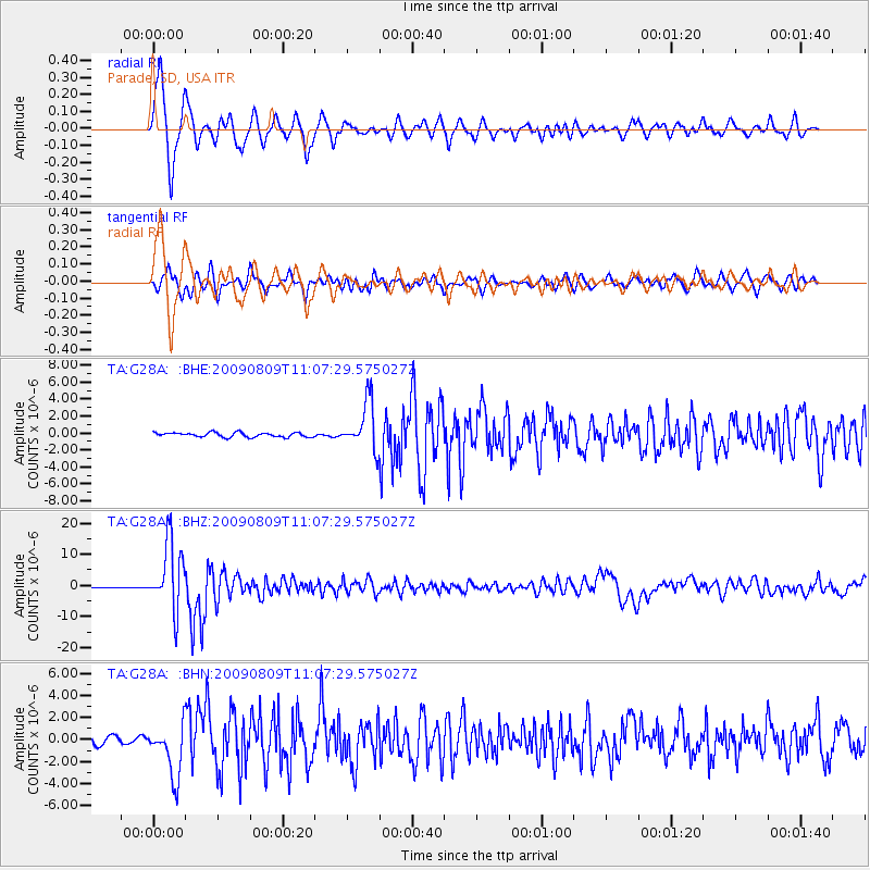
| Radial Match: |
90.22805 % |
| Radial Bump: |
400 |
| Transverse Match: |
84.3668 % |
| Transverse Bump: |
400 |
| SOD ConfigId: |
2622 |
| Insert Time: |
2010-03-06 02:24:48.175 +0000 |
| GWidth: |
2.5 |
| Max Bumps: |
400 |
| Tol: |
0.001 |
|
Signal To Noise
| Channel | StoN | STA | LTA |
| TA:G28A: :BHZ:20090809T11:07:29.575027Z | 93.411896 | 1.0877379E-5 | 1.1644533E-7 |
| TA:G28A: :BHN:20090809T11:07:29.575027Z | 5.046064 | 2.400291E-6 | 4.756759E-7 |
| TA:G28A: :BHE:20090809T11:07:29.575027Z | 10.885954 | 2.8301745E-6 | 2.5998406E-7 |
| Arrivals |
| Ps | 4.9 SECOND |
| PpPs | 19 SECOND |
| PsPs/PpSs | 24 SECOND |


