You are here: Home > Network List > TA - USArray Transportable Network (new EarthScope stations) Stations List
> Station G28A Parade, SD, USA > Earthquake Result Viewer
G28A Parade, SD, USA - Earthquake Result Viewer
| Earthquake location: |
Southeast Of Honshu, Japan |
| Earthquake latitude/longitude: |
32.8/140.4 |
| Earthquake time(UTC): |
2009/08/12 (224) 22:48:51 GMT |
| Earthquake Depth: |
53 km |
| Earthquake Magnitude: |
6.2 MB, 6.6 MW, 6.6 MW |
| Earthquake Catalog/Contributor: |
WHDF/NEIC |
|
| Network: |
TA USArray Transportable Network (new EarthScope stations) |
| Station: |
G28A Parade, SD, USA |
| Lat/Lon: |
45.07 N/100.92 W |
| Elevation: |
709 m |
|
| Distance: |
84.6 deg |
| Az: |
38.635 deg |
| Baz: |
312.102 deg |
| Ray Param: |
0.04527874 |
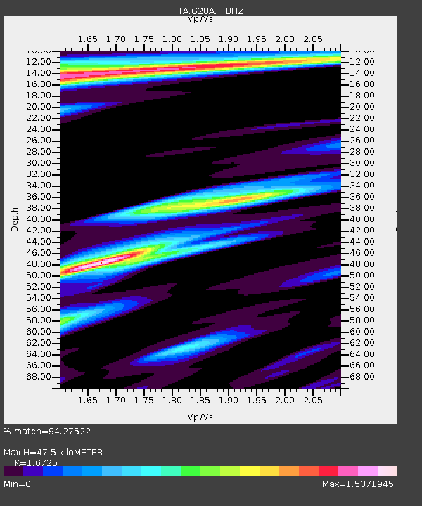
| Estimated Moho Depth: |
47.5 km |
| Estimated Crust Vp/Vs: |
1.67 |
| Assumed Crust Vp: |
6.53 km/s |
| Estimated Crust Vs: |
3.905 km/s |
| Estimated Crust Poisson's Ratio: |
0.22 |
|
| Radial Match: |
94.27522 % |
| Radial Bump: |
400 |
| Transverse Match: |
86.18431 % |
| Transverse Bump: |
400 |
| SOD ConfigId: |
2622 |
| Insert Time: |
2010-03-06 02:24:49.933 +0000 |
| GWidth: |
2.5 |
| Max Bumps: |
400 |
| Tol: |
0.001 |
|
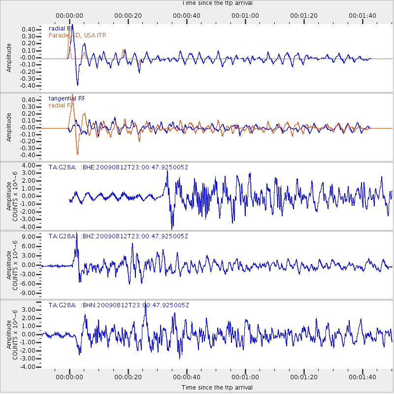
Signal To Noise
| Channel | StoN | STA | LTA |
| TA:G28A: :BHZ:20090812T23:00:47.925005Z | 26.078762 | 3.3140545E-6 | 1.2707866E-7 |
| TA:G28A: :BHN:20090812T23:00:47.925005Z | 4.486897 | 9.0230265E-7 | 2.0109724E-7 |
| TA:G28A: :BHE:20090812T23:00:47.925005Z | 3.864828 | 1.2470415E-6 | 3.2266416E-7 |
| Arrivals |
| Ps | 5.0 SECOND |
| PpPs | 19 SECOND |
| PsPs/PpSs | 24 SECOND |


