You are here: Home > Network List > TA - USArray Transportable Network (new EarthScope stations) Stations List
> Station G28A Parade, SD, USA > Earthquake Result Viewer
G28A Parade, SD, USA - Earthquake Result Viewer
| Earthquake location: |
Azores Islands Region |
| Earthquake latitude/longitude: |
36.2/-33.9 |
| Earthquake time(UTC): |
2009/11/04 (308) 18:41:44 GMT |
| Earthquake Depth: |
10 km |
| Earthquake Magnitude: |
5.7 MB, 5.6 MS, 5.9 MW, 5.8 MW |
| Earthquake Catalog/Contributor: |
WHDF/NEIC |
|
| Network: |
TA USArray Transportable Network (new EarthScope stations) |
| Station: |
G28A Parade, SD, USA |
| Lat/Lon: |
45.07 N/100.92 W |
| Elevation: |
709 m |
|
| Distance: |
50.3 deg |
| Az: |
302.068 deg |
| Baz: |
75.449 deg |
| Ray Param: |
0.06811974 |
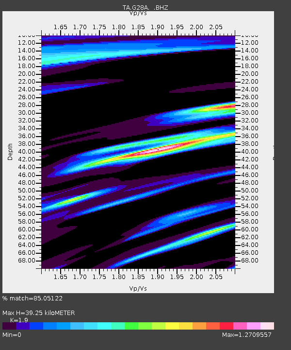
| Estimated Moho Depth: |
39.25 km |
| Estimated Crust Vp/Vs: |
1.90 |
| Assumed Crust Vp: |
6.53 km/s |
| Estimated Crust Vs: |
3.437 km/s |
| Estimated Crust Poisson's Ratio: |
0.31 |
|
| Radial Match: |
85.05122 % |
| Radial Bump: |
369 |
| Transverse Match: |
69.557144 % |
| Transverse Bump: |
335 |
| SOD ConfigId: |
2622 |
| Insert Time: |
2010-03-06 02:25:02.337 +0000 |
| GWidth: |
2.5 |
| Max Bumps: |
400 |
| Tol: |
0.001 |
|
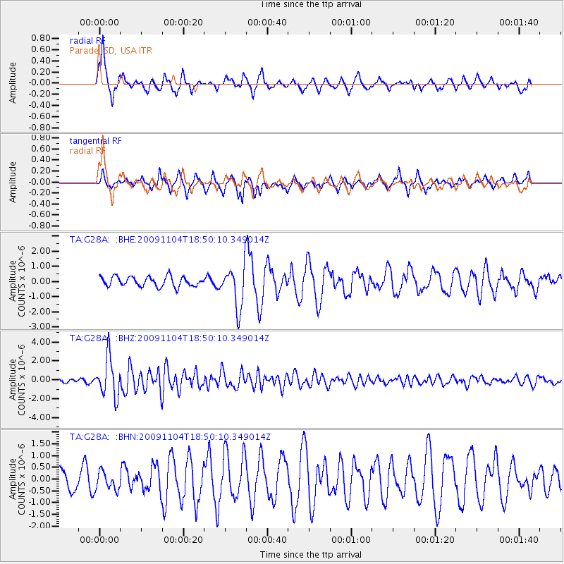
Signal To Noise
| Channel | StoN | STA | LTA |
| TA:G28A: :BHZ:20091104T18:50:10.349014Z | 12.90127 | 2.0964694E-6 | 1.6250101E-7 |
| TA:G28A: :BHN:20091104T18:50:10.349014Z | 0.5522936 | 3.765182E-7 | 6.8173557E-7 |
| TA:G28A: :BHE:20091104T18:50:10.349014Z | 4.396437 | 1.4156487E-6 | 3.219991E-7 |
| Arrivals |
| Ps | 5.7 SECOND |
| PpPs | 16 SECOND |
| PsPs/PpSs | 22 SECOND |


