You are here: Home > Network List > TA - USArray Transportable Network (new EarthScope stations) Stations List
> Station G28A Parade, SD, USA > Earthquake Result Viewer
G28A Parade, SD, USA - Earthquake Result Viewer
| Earthquake location: |
Baffin Bay |
| Earthquake latitude/longitude: |
75.4/-72.5 |
| Earthquake time(UTC): |
2009/07/07 (188) 19:11:46 GMT |
| Earthquake Depth: |
19 km |
| Earthquake Magnitude: |
5.9 MB, 5.7 MS, 6.1 MW, 6.0 MW |
| Earthquake Catalog/Contributor: |
WHDF/NEIC |
|
| Network: |
TA USArray Transportable Network (new EarthScope stations) |
| Station: |
G28A Parade, SD, USA |
| Lat/Lon: |
45.07 N/100.92 W |
| Elevation: |
709 m |
|
| Distance: |
32.8 deg |
| Az: |
218.613 deg |
| Baz: |
12.953 deg |
| Ray Param: |
0.07849718 |
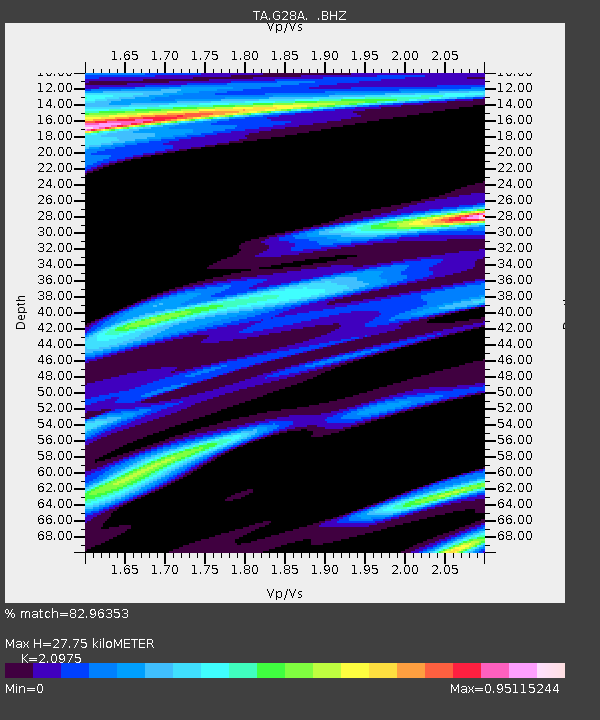
| Estimated Moho Depth: |
27.75 km |
| Estimated Crust Vp/Vs: |
2.10 |
| Assumed Crust Vp: |
6.53 km/s |
| Estimated Crust Vs: |
3.113 km/s |
| Estimated Crust Poisson's Ratio: |
0.35 |
|
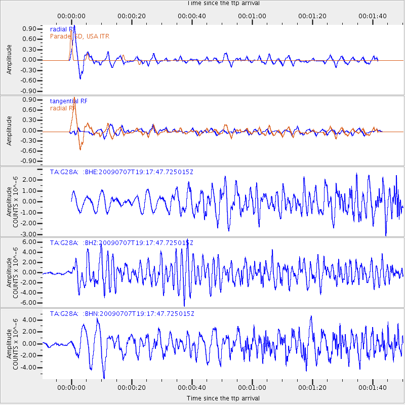
| Radial Match: |
82.96353 % |
| Radial Bump: |
400 |
| Transverse Match: |
75.151054 % |
| Transverse Bump: |
400 |
| SOD ConfigId: |
2648 |
| Insert Time: |
2010-03-06 02:25:08.926 +0000 |
| GWidth: |
2.5 |
| Max Bumps: |
400 |
| Tol: |
0.001 |
|
Signal To Noise
| Channel | StoN | STA | LTA |
| TA:G28A: :BHZ:20090707T19:17:47.725015Z | 14.386996 | 1.881523E-6 | 1.3077941E-7 |
| TA:G28A: :BHN:20090707T19:17:47.725015Z | 3.8297732 | 1.7523226E-6 | 4.575526E-7 |
| TA:G28A: :BHE:20090707T19:17:47.725015Z | 1.0823523 | 6.031496E-7 | 5.5725815E-7 |
| Arrivals |
| Ps | 5.0 SECOND |
| PpPs | 12 SECOND |
| PsPs/PpSs | 17 SECOND |


