You are here: Home > Network List > TA - USArray Transportable Network (new EarthScope stations) Stations List
> Station H28A Mission Ridge, SD, USA > Earthquake Result Viewer
H28A Mission Ridge, SD, USA - Earthquake Result Viewer
| Earthquake location: |
Crete, Greece |
| Earthquake latitude/longitude: |
34.2/25.5 |
| Earthquake time(UTC): |
2009/07/01 (182) 09:30:10 GMT |
| Earthquake Depth: |
19 km |
| Earthquake Magnitude: |
6.1 MB, 6.3 MS, 6.4 MW, 6.4 MW |
| Earthquake Catalog/Contributor: |
WHDF/NEIC |
|
| Network: |
TA USArray Transportable Network (new EarthScope stations) |
| Station: |
H28A Mission Ridge, SD, USA |
| Lat/Lon: |
44.68 N/101.02 W |
| Elevation: |
642 m |
|
| Distance: |
87.7 deg |
| Az: |
324.968 deg |
| Baz: |
41.847 deg |
| Ray Param: |
0.043107767 |
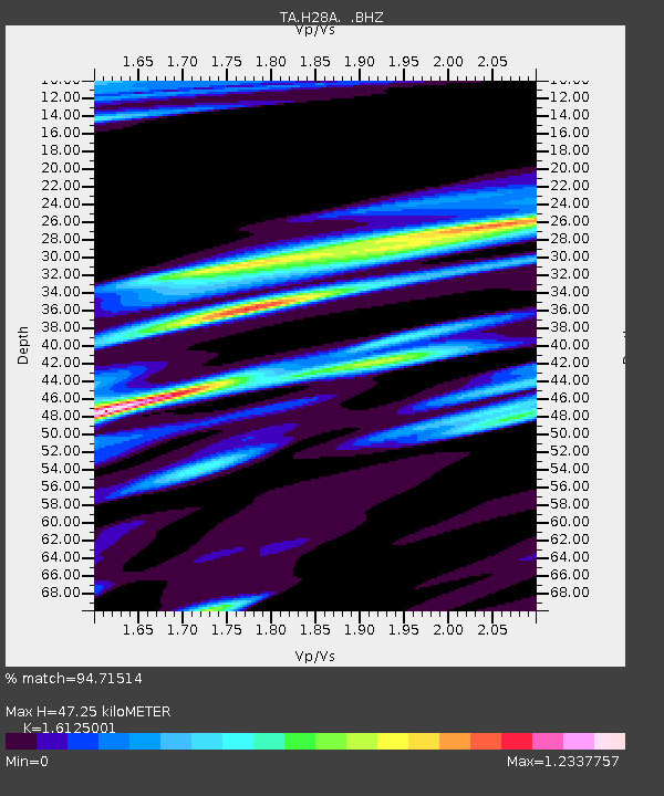
| Estimated Moho Depth: |
47.25 km |
| Estimated Crust Vp/Vs: |
1.61 |
| Assumed Crust Vp: |
6.53 km/s |
| Estimated Crust Vs: |
4.05 km/s |
| Estimated Crust Poisson's Ratio: |
0.19 |
|
| Radial Match: |
94.71514 % |
| Radial Bump: |
383 |
| Transverse Match: |
75.516716 % |
| Transverse Bump: |
400 |
| SOD ConfigId: |
2622 |
| Insert Time: |
2010-03-06 02:25:24.916 +0000 |
| GWidth: |
2.5 |
| Max Bumps: |
400 |
| Tol: |
0.001 |
|
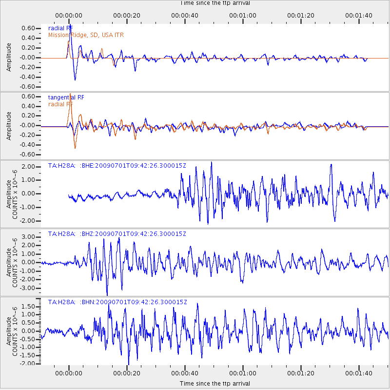
Signal To Noise
| Channel | StoN | STA | LTA |
| TA:H28A: :BHZ:20090701T09:42:26.300015Z | 3.144429 | 2.7868768E-7 | 8.862903E-8 |
| TA:H28A: :BHN:20090701T09:42:26.300015Z | 0.72664934 | 1.7997431E-7 | 2.4767698E-7 |
| TA:H28A: :BHE:20090701T09:42:26.300015Z | 1.6976572 | 2.913065E-7 | 1.7159323E-7 |
| Arrivals |
| Ps | 4.5 SECOND |
| PpPs | 18 SECOND |
| PsPs/PpSs | 23 SECOND |


