You are here: Home > Network List > TA - USArray Transportable Network (new EarthScope stations) Stations List
> Station H28A Mission Ridge, SD, USA > Earthquake Result Viewer
H28A Mission Ridge, SD, USA - Earthquake Result Viewer
| Earthquake location: |
Norwegian Sea |
| Earthquake latitude/longitude: |
72.2/0.9 |
| Earthquake time(UTC): |
2009/08/20 (232) 06:35:04 GMT |
| Earthquake Depth: |
6.0 km |
| Earthquake Magnitude: |
5.9 MB, 5.7 MS, 6.0 MW, 6.0 MW |
| Earthquake Catalog/Contributor: |
WHDF/NEIC |
|
| Network: |
TA USArray Transportable Network (new EarthScope stations) |
| Station: |
H28A Mission Ridge, SD, USA |
| Lat/Lon: |
44.68 N/101.02 W |
| Elevation: |
642 m |
|
| Distance: |
51.6 deg |
| Az: |
297.04 deg |
| Baz: |
22.579 deg |
| Ray Param: |
0.06732353 |
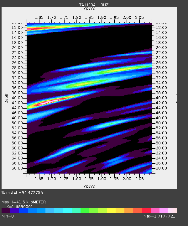
| Estimated Moho Depth: |
41.5 km |
| Estimated Crust Vp/Vs: |
1.69 |
| Assumed Crust Vp: |
6.53 km/s |
| Estimated Crust Vs: |
3.876 km/s |
| Estimated Crust Poisson's Ratio: |
0.23 |
|
| Radial Match: |
94.472755 % |
| Radial Bump: |
400 |
| Transverse Match: |
73.20077 % |
| Transverse Bump: |
400 |
| SOD ConfigId: |
2622 |
| Insert Time: |
2010-03-06 02:25:26.638 +0000 |
| GWidth: |
2.5 |
| Max Bumps: |
400 |
| Tol: |
0.001 |
|
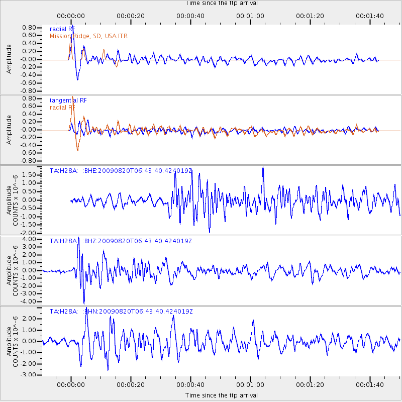
Signal To Noise
| Channel | StoN | STA | LTA |
| TA:H28A: :BHZ:20090820T06:43:40.424019Z | 19.263754 | 1.8348111E-6 | 9.524681E-8 |
| TA:H28A: :BHN:20090820T06:43:40.424019Z | 5.44243 | 7.994549E-7 | 1.46893E-7 |
| TA:H28A: :BHE:20090820T06:43:40.424019Z | 2.416535 | 5.1297417E-7 | 2.1227676E-7 |
| Arrivals |
| Ps | 4.6 SECOND |
| PpPs | 16 SECOND |
| PsPs/PpSs | 21 SECOND |


