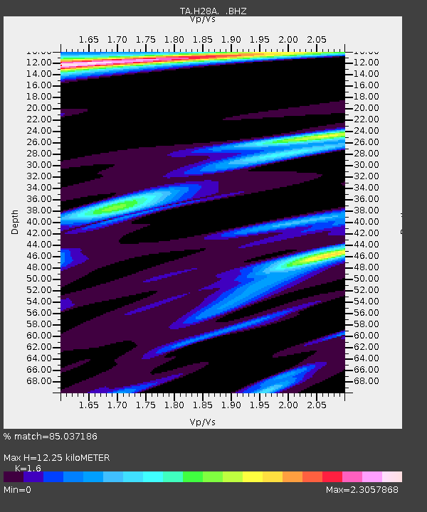
H28A Mission Ridge, SD, USA - Earthquake Result Viewer
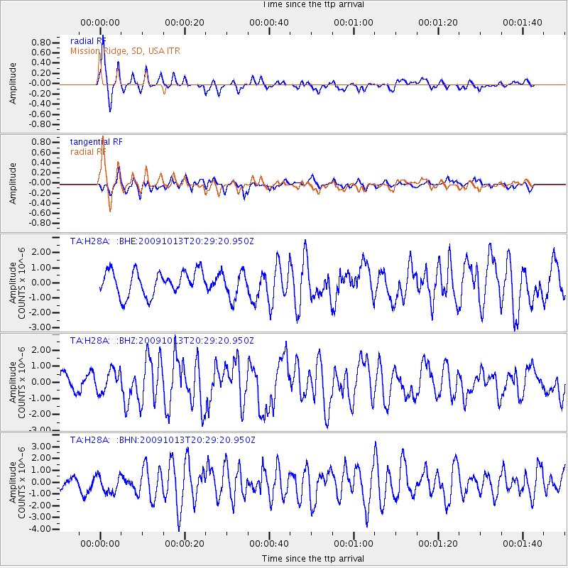
Earthquake location: Fox Islands, Aleutian Islands
Earthquake latitude/longitude: 52.6/-167.1
Earthquake time(UTC): 2009/10/13 (286) 20:21:53 GMT
Earthquake Depth: 14 km
Earthquake Magnitude: 5.9 MB, 6.4 MS, 6.4 MW, 6.4 MW
Earthquake Catalog/Contributor: WHDF/NEIC
Network: TA USArray Transportable Network (new EarthScope stations)
Station: H28A Mission Ridge, SD, USA
Lat/Lon: 44.68 N/101.02 W
Elevation: 642 m
Distance: 43.0 deg
Az: 73.094 deg
Baz: 305.126 deg
Ray Param: 0.07283475
Estimated Moho Depth: 12.25 km
Estimated Crust Vp/Vs: 1.60
Assumed Crust Vp: 6.53 km/s
Estimated Crust Vs: 4.082 km/s
Estimated Crust Poisson's Ratio: 0.18
Radial Match: 85.037186 %
Radial Bump: 400
Transverse Match: 77.89247 %
Transverse Bump: 400
SOD ConfigId: 2622
Insert Time: 2010-03-06 02:25:32.473 +0000
GWidth: 2.5
Max Bumps: 400
Tol: 0.001

Signal To Noise

ChannelStoNSTALTA
TA:H28A: :BHZ:20091013T20:29:20.950Z1.79650647.044213E-73.9210622E-7
TA:H28A: :BHN:20091013T20:29:20.950Z2.61094077.9565194E-73.0473765E-7
TA:H28A: :BHE:20091013T20:29:20.950Z1.13669769.021792E-77.936844E-7
Arrivals
Ps1.2 SECOND
PpPs4.5 SECOND
PsPs/PpSs5.7 SECOND