You are here: Home > Network List > TA - USArray Transportable Network (new EarthScope stations) Stations List
> Station H28A Mission Ridge, SD, USA > Earthquake Result Viewer
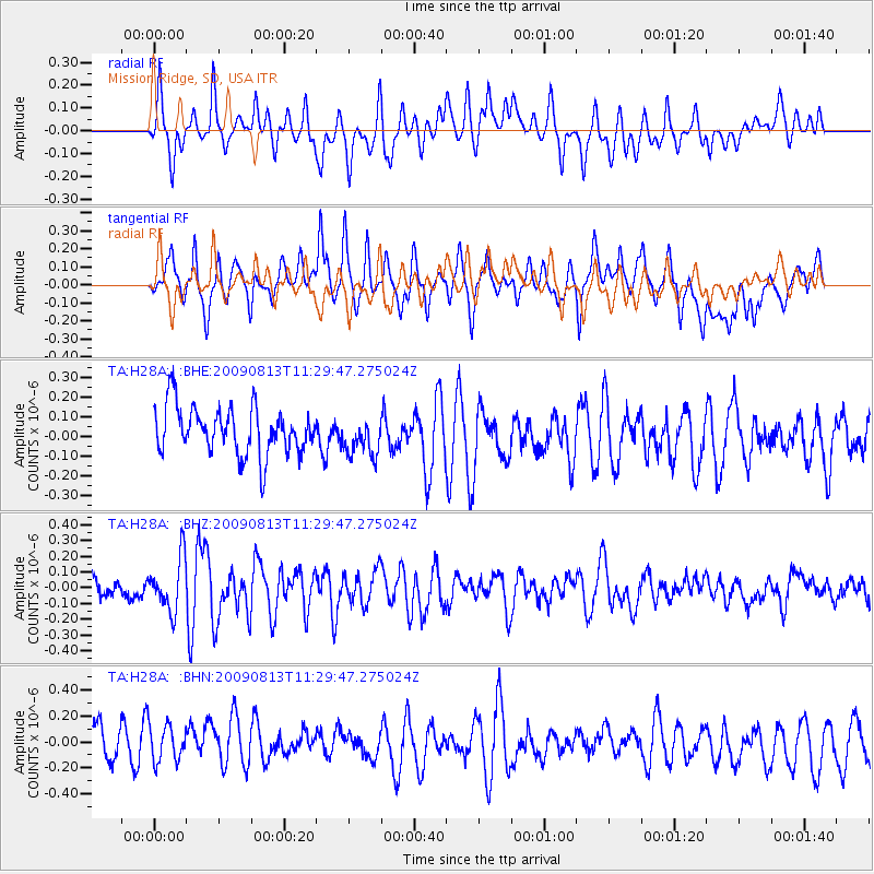
H28A Mission Ridge, SD, USA - Earthquake Result Viewer
*The percent match for this event was below the threshold and hence no stack was calculated.
| Earthquake location: |
Tonga Islands |
| Earthquake latitude/longitude: |
-21.7/-174.6 |
| Earthquake time(UTC): |
2009/08/13 (225) 11:17:01 GMT |
| Earthquake Depth: |
10 km |
| Earthquake Magnitude: |
5.6 MW, 5.3 MB |
| Earthquake Catalog/Contributor: |
WHDF/NEIC |
|
| Network: |
TA USArray Transportable Network (new EarthScope stations) |
| Station: |
H28A Mission Ridge, SD, USA |
| Lat/Lon: |
44.68 N/101.02 W |
| Elevation: |
642 m |
|
| Distance: |
94.0 deg |
| Az: |
43.305 deg |
| Baz: |
243.414 deg |
| Ray Param: |
$rayparam |
*The percent match for this event was below the threshold and hence was not used in the summary stack. |
|
| Radial Match: |
61.71535 % |
| Radial Bump: |
400 |
| Transverse Match: |
56.41814 % |
| Transverse Bump: |
400 |
| SOD ConfigId: |
2622 |
| Insert Time: |
2010-03-06 02:25:49.854 +0000 |
| GWidth: |
2.5 |
| Max Bumps: |
400 |
| Tol: |
0.001 |
|
Signal To Noise
| Channel | StoN | STA | LTA |
| TA:H28A: :BHZ:20090813T11:29:47.275024Z | 2.6638112 | 1.6724114E-7 | 6.2782654E-8 |
| TA:H28A: :BHN:20090813T11:29:47.275024Z | 1.0816444 | 1.4988345E-7 | 1.3856999E-7 |
| TA:H28A: :BHE:20090813T11:29:47.275024Z | 0.8048671 | 9.636501E-8 | 1.1972786E-7 |
| Arrivals |
| Ps | |
| PpPs | |
| PsPs/PpSs | |


