You are here: Home > Network List > TA - USArray Transportable Network (new EarthScope stations) Stations List
> Station D23K Nanushuk River, AK USA > Earthquake Result Viewer
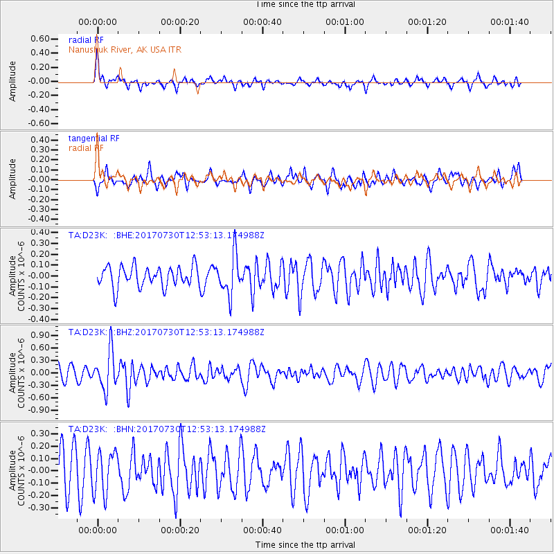
D23K Nanushuk River, AK USA - Earthquake Result Viewer
*The percent match for this event was below the threshold and hence no stack was calculated.
| Earthquake location: |
Off East Coast Of Honshu, Japan |
| Earthquake latitude/longitude: |
36.3/143.7 |
| Earthquake time(UTC): |
2017/07/30 (211) 12:45:06 GMT |
| Earthquake Depth: |
17 km |
| Earthquake Magnitude: |
5.3 Mww |
| Earthquake Catalog/Contributor: |
NEIC PDE/us |
|
| Network: |
TA USArray Transportable Network (new EarthScope stations) |
| Station: |
D23K Nanushuk River, AK USA |
| Lat/Lon: |
68.97 N/150.68 W |
| Elevation: |
406 m |
|
| Distance: |
47.9 deg |
| Az: |
26.292 deg |
| Baz: |
262.393 deg |
| Ray Param: |
$rayparam |
*The percent match for this event was below the threshold and hence was not used in the summary stack. |
|
| Radial Match: |
59.505367 % |
| Radial Bump: |
400 |
| Transverse Match: |
65.4348 % |
| Transverse Bump: |
400 |
| SOD ConfigId: |
13570011 |
| Insert Time: |
2019-04-28 12:15:50.123 +0000 |
| GWidth: |
2.5 |
| Max Bumps: |
400 |
| Tol: |
0.001 |
|
Signal To Noise
| Channel | StoN | STA | LTA |
| TA:D23K: :BHZ:20170730T12:53:13.174988Z | 2.2328358 | 4.6855413E-7 | 2.0984712E-7 |
| TA:D23K: :BHN:20170730T12:53:13.174988Z | 1.3366452 | 1.714514E-7 | 1.2826995E-7 |
| TA:D23K: :BHE:20170730T12:53:13.174988Z | 1.9847227 | 1.8724305E-7 | 9.434217E-8 |
| Arrivals |
| Ps | |
| PpPs | |
| PsPs/PpSs | |


