You are here: Home > Network List > TA - USArray Transportable Network (new EarthScope stations) Stations List
> Station D25K Kavik River, AK, USA > Earthquake Result Viewer
D25K Kavik River, AK, USA - Earthquake Result Viewer
*The percent match for this event was below the threshold and hence no stack was calculated.
| Earthquake location: |
Off East Coast Of Honshu, Japan |
| Earthquake latitude/longitude: |
36.3/143.7 |
| Earthquake time(UTC): |
2017/07/30 (211) 12:45:06 GMT |
| Earthquake Depth: |
17 km |
| Earthquake Magnitude: |
5.3 Mww |
| Earthquake Catalog/Contributor: |
NEIC PDE/us |
|
| Network: |
TA USArray Transportable Network (new EarthScope stations) |
| Station: |
D25K Kavik River, AK, USA |
| Lat/Lon: |
69.32 N/146.38 W |
| Elevation: |
770 m |
|
| Distance: |
49.5 deg |
| Az: |
26.022 deg |
| Baz: |
266.235 deg |
| Ray Param: |
$rayparam |
*The percent match for this event was below the threshold and hence was not used in the summary stack. |
|
| Radial Match: |
52.958942 % |
| Radial Bump: |
400 |
| Transverse Match: |
54.033768 % |
| Transverse Bump: |
400 |
| SOD ConfigId: |
13570011 |
| Insert Time: |
2019-04-28 12:15:52.330 +0000 |
| GWidth: |
2.5 |
| Max Bumps: |
400 |
| Tol: |
0.001 |
|
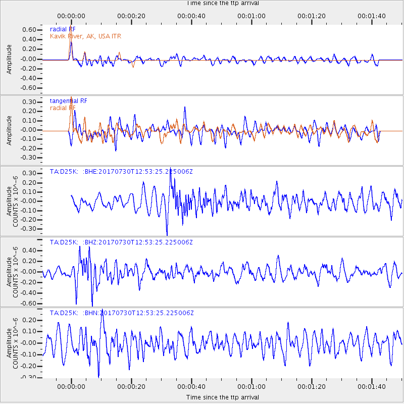
Signal To Noise
| Channel | StoN | STA | LTA |
| TA:D25K: :BHZ:20170730T12:53:25.225006Z | 4.265892 | 2.1609154E-7 | 5.0655654E-8 |
| TA:D25K: :BHN:20170730T12:53:25.225006Z | 1.5000479 | 9.2646445E-8 | 6.176233E-8 |
| TA:D25K: :BHE:20170730T12:53:25.225006Z | 2.53669 | 1.6595602E-7 | 6.542228E-8 |
| Arrivals |
| Ps | |
| PpPs | |
| PsPs/PpSs | |


