You are here: Home > Network List > TA - USArray Transportable Network (new EarthScope stations) Stations List
> Station H28A Mission Ridge, SD, USA > Earthquake Result Viewer
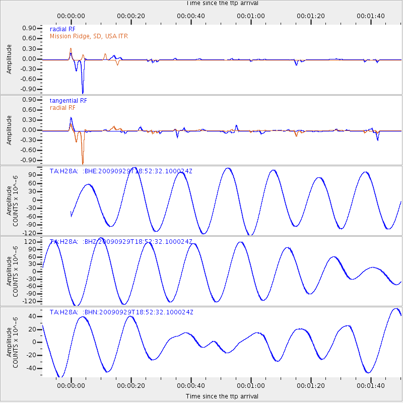
H28A Mission Ridge, SD, USA - Earthquake Result Viewer
*The percent match for this event was below the threshold and hence no stack was calculated.
| Earthquake location: |
Tonga Islands |
| Earthquake latitude/longitude: |
-15.4/-173.2 |
| Earthquake time(UTC): |
2009/09/29 (272) 18:40:09 GMT |
| Earthquake Depth: |
2.3 km |
| Earthquake Magnitude: |
5.5 MB |
| Earthquake Catalog/Contributor: |
WHDF/NEIC |
|
| Network: |
TA USArray Transportable Network (new EarthScope stations) |
| Station: |
H28A Mission Ridge, SD, USA |
| Lat/Lon: |
44.68 N/101.02 W |
| Elevation: |
642 m |
|
| Distance: |
88.5 deg |
| Az: |
42.813 deg |
| Baz: |
246.774 deg |
| Ray Param: |
$rayparam |
*The percent match for this event was below the threshold and hence was not used in the summary stack. |
|
| Radial Match: |
97.39435 % |
| Radial Bump: |
224 |
| Transverse Match: |
92.94706 % |
| Transverse Bump: |
387 |
| SOD ConfigId: |
2622 |
| Insert Time: |
2010-03-06 02:25:59.330 +0000 |
| GWidth: |
2.5 |
| Max Bumps: |
400 |
| Tol: |
0.001 |
|
Signal To Noise
| Channel | StoN | STA | LTA |
| TA:H28A: :BHZ:20090929T18:52:32.100024Z | 1.4508162 | 1.1594123E-4 | 7.9914484E-5 |
| TA:H28A: :BHN:20090929T18:52:32.100024Z | 0.71769136 | 2.6007703E-5 | 3.6238005E-5 |
| TA:H28A: :BHE:20090929T18:52:32.100024Z | 1.1058657 | 7.072472E-5 | 6.395417E-5 |
| Arrivals |
| Ps | |
| PpPs | |
| PsPs/PpSs | |


