You are here: Home > Network List > TA - USArray Transportable Network (new EarthScope stations) Stations List
> Station F26K Sheenjek River, AK, USA > Earthquake Result Viewer
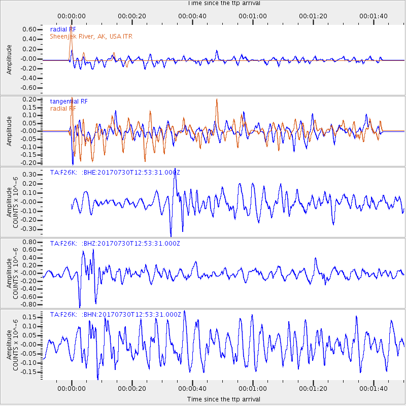
F26K Sheenjek River, AK, USA - Earthquake Result Viewer
*The percent match for this event was below the threshold and hence no stack was calculated.
| Earthquake location: |
Off East Coast Of Honshu, Japan |
| Earthquake latitude/longitude: |
36.3/143.7 |
| Earthquake time(UTC): |
2017/07/30 (211) 12:45:06 GMT |
| Earthquake Depth: |
17 km |
| Earthquake Magnitude: |
5.3 Mww |
| Earthquake Catalog/Contributor: |
NEIC PDE/us |
|
| Network: |
TA USArray Transportable Network (new EarthScope stations) |
| Station: |
F26K Sheenjek River, AK, USA |
| Lat/Lon: |
67.69 N/144.15 W |
| Elevation: |
683 m |
|
| Distance: |
50.3 deg |
| Az: |
28.197 deg |
| Baz: |
269.709 deg |
| Ray Param: |
$rayparam |
*The percent match for this event was below the threshold and hence was not used in the summary stack. |
|
| Radial Match: |
50.761215 % |
| Radial Bump: |
400 |
| Transverse Match: |
50.459858 % |
| Transverse Bump: |
385 |
| SOD ConfigId: |
13570011 |
| Insert Time: |
2019-04-28 12:16:06.158 +0000 |
| GWidth: |
2.5 |
| Max Bumps: |
400 |
| Tol: |
0.001 |
|
Signal To Noise
| Channel | StoN | STA | LTA |
| TA:F26K: :BHZ:20170730T12:53:31.000Z | 3.4447103 | 3.23343E-7 | 9.386652E-8 |
| TA:F26K: :BHN:20170730T12:53:31.000Z | 1.4141964 | 6.9142445E-8 | 4.889169E-8 |
| TA:F26K: :BHE:20170730T12:53:31.000Z | 3.53064 | 1.7293631E-7 | 4.8981576E-8 |
| Arrivals |
| Ps | |
| PpPs | |
| PsPs/PpSs | |


