You are here: Home > Network List > TA - USArray Transportable Network (new EarthScope stations) Stations List
> Station H28A Mission Ridge, SD, USA > Earthquake Result Viewer
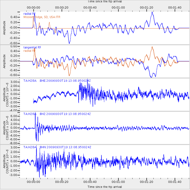
H28A Mission Ridge, SD, USA - Earthquake Result Viewer
*The percent match for this event was below the threshold and hence no stack was calculated.
| Earthquake location: |
Peru-Bolivia Border Region |
| Earthquake latitude/longitude: |
-15.6/-69.3 |
| Earthquake time(UTC): |
2009/09/30 (273) 19:03:17 GMT |
| Earthquake Depth: |
255 km |
| Earthquake Magnitude: |
5.9 MB, 5.8 MW |
| Earthquake Catalog/Contributor: |
WHDF/NEIC |
|
| Network: |
TA USArray Transportable Network (new EarthScope stations) |
| Station: |
H28A Mission Ridge, SD, USA |
| Lat/Lon: |
44.68 N/101.02 W |
| Elevation: |
642 m |
|
| Distance: |
66.5 deg |
| Az: |
335.856 deg |
| Baz: |
146.456 deg |
| Ray Param: |
$rayparam |
*The percent match for this event was below the threshold and hence was not used in the summary stack. |
|
| Radial Match: |
45.58569 % |
| Radial Bump: |
400 |
| Transverse Match: |
49.709255 % |
| Transverse Bump: |
400 |
| SOD ConfigId: |
2622 |
| Insert Time: |
2010-03-06 02:25:59.901 +0000 |
| GWidth: |
2.5 |
| Max Bumps: |
400 |
| Tol: |
0.001 |
|
Signal To Noise
| Channel | StoN | STA | LTA |
| TA:H28A: :BHZ:20090930T19:13:08.950024Z | 11.870057 | 2.9745433E-6 | 2.5059217E-7 |
| TA:H28A: :BHN:20090930T19:13:08.950024Z | 4.669489 | 1.3149707E-6 | 2.8160915E-7 |
| TA:H28A: :BHE:20090930T19:13:08.950024Z | 2.0453603 | 1.4647801E-6 | 7.1614767E-7 |
| Arrivals |
| Ps | |
| PpPs | |
| PsPs/PpSs | |


