You are here: Home > Network List > TA - USArray Transportable Network (new EarthScope stations) Stations List
> Station H31M Peel River, Yukon, CAN > Earthquake Result Viewer
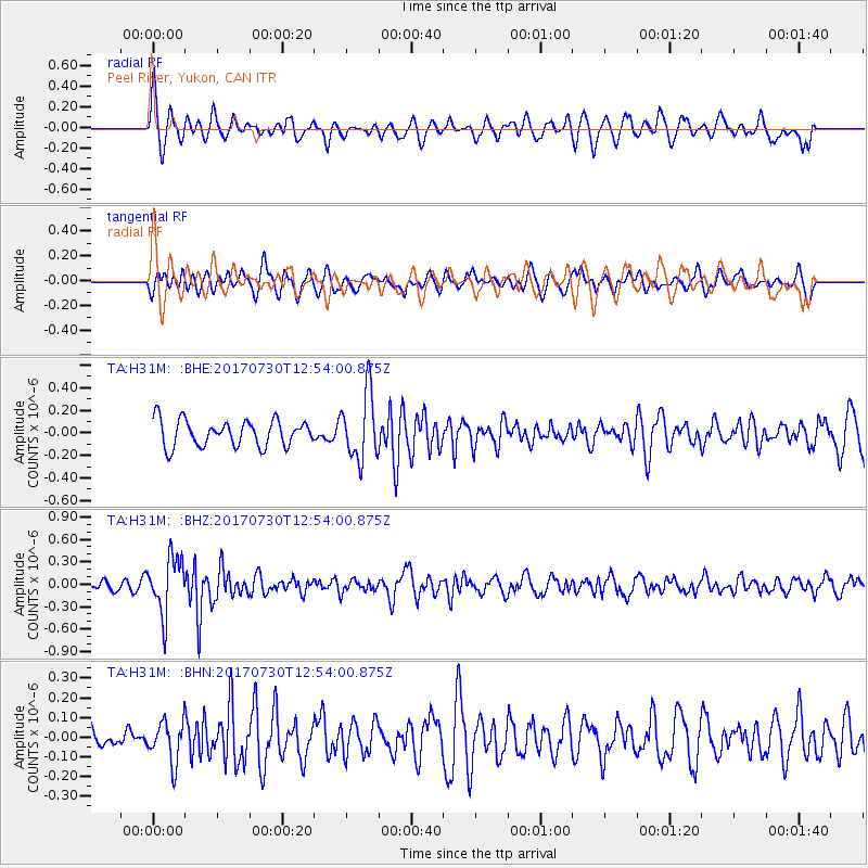
H31M Peel River, Yukon, CAN - Earthquake Result Viewer
*The percent match for this event was below the threshold and hence no stack was calculated.
| Earthquake location: |
Off East Coast Of Honshu, Japan |
| Earthquake latitude/longitude: |
36.3/143.7 |
| Earthquake time(UTC): |
2017/07/30 (211) 12:45:06 GMT |
| Earthquake Depth: |
17 km |
| Earthquake Magnitude: |
5.3 Mww |
| Earthquake Catalog/Contributor: |
NEIC PDE/us |
|
| Network: |
TA USArray Transportable Network (new EarthScope stations) |
| Station: |
H31M Peel River, Yukon, CAN |
| Lat/Lon: |
65.81 N/134.34 W |
| Elevation: |
642 m |
|
| Distance: |
54.3 deg |
| Az: |
30.167 deg |
| Baz: |
279.917 deg |
| Ray Param: |
$rayparam |
*The percent match for this event was below the threshold and hence was not used in the summary stack. |
|
| Radial Match: |
63.841534 % |
| Radial Bump: |
400 |
| Transverse Match: |
49.826122 % |
| Transverse Bump: |
400 |
| SOD ConfigId: |
13570011 |
| Insert Time: |
2019-04-28 12:16:25.153 +0000 |
| GWidth: |
2.5 |
| Max Bumps: |
400 |
| Tol: |
0.001 |
|
Signal To Noise
| Channel | StoN | STA | LTA |
| TA:H31M: :BHZ:20170730T12:54:00.875Z | 3.5058231 | 3.723834E-7 | 1.0621853E-7 |
| TA:H31M: :BHN:20170730T12:54:00.875Z | 1.2501631 | 1.0488035E-7 | 8.389333E-8 |
| TA:H31M: :BHE:20170730T12:54:00.875Z | 2.570629 | 2.9456686E-7 | 1.1458942E-7 |
| Arrivals |
| Ps | |
| PpPs | |
| PsPs/PpSs | |


