You are here: Home > Network List > TA - USArray Transportable Network (new EarthScope stations) Stations List
> Station I17K Unalakleet, AK, USA > Earthquake Result Viewer
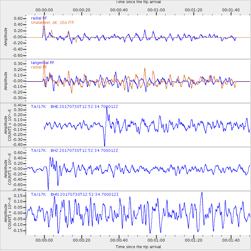
I17K Unalakleet, AK, USA - Earthquake Result Viewer
*The percent match for this event was below the threshold and hence no stack was calculated.
| Earthquake location: |
Off East Coast Of Honshu, Japan |
| Earthquake latitude/longitude: |
36.3/143.7 |
| Earthquake time(UTC): |
2017/07/30 (211) 12:45:06 GMT |
| Earthquake Depth: |
17 km |
| Earthquake Magnitude: |
5.3 Mww |
| Earthquake Catalog/Contributor: |
NEIC PDE/us |
|
| Network: |
TA USArray Transportable Network (new EarthScope stations) |
| Station: |
I17K Unalakleet, AK, USA |
| Lat/Lon: |
63.89 N/160.70 W |
| Elevation: |
105 m |
|
| Distance: |
43.1 deg |
| Az: |
32.322 deg |
| Baz: |
257.443 deg |
| Ray Param: |
$rayparam |
*The percent match for this event was below the threshold and hence was not used in the summary stack. |
|
| Radial Match: |
64.874016 % |
| Radial Bump: |
390 |
| Transverse Match: |
66.96344 % |
| Transverse Bump: |
400 |
| SOD ConfigId: |
13570011 |
| Insert Time: |
2019-04-28 12:16:25.890 +0000 |
| GWidth: |
2.5 |
| Max Bumps: |
400 |
| Tol: |
0.001 |
|
Signal To Noise
| Channel | StoN | STA | LTA |
| TA:I17K: :BHZ:20170730T12:52:34.700012Z | 4.5946913 | 2.8515348E-7 | 6.206151E-8 |
| TA:I17K: :BHN:20170730T12:52:34.700012Z | 0.86691475 | 4.805508E-8 | 5.5432306E-8 |
| TA:I17K: :BHE:20170730T12:52:34.700012Z | 4.428394 | 1.8084847E-7 | 4.083839E-8 |
| Arrivals |
| Ps | |
| PpPs | |
| PsPs/PpSs | |


