You are here: Home > Network List > TA - USArray Transportable Network (new EarthScope stations) Stations List
> Station I27A Quinn, SD, USA > Earthquake Result Viewer
I27A Quinn, SD, USA - Earthquake Result Viewer
| Earthquake location: |
Crete, Greece |
| Earthquake latitude/longitude: |
34.2/25.5 |
| Earthquake time(UTC): |
2009/07/01 (182) 09:30:10 GMT |
| Earthquake Depth: |
19 km |
| Earthquake Magnitude: |
6.1 MB, 6.3 MS, 6.4 MW, 6.4 MW |
| Earthquake Catalog/Contributor: |
WHDF/NEIC |
|
| Network: |
TA USArray Transportable Network (new EarthScope stations) |
| Station: |
I27A Quinn, SD, USA |
| Lat/Lon: |
44.07 N/102.05 W |
| Elevation: |
867 m |
|
| Distance: |
88.7 deg |
| Az: |
325.121 deg |
| Baz: |
41.133 deg |
| Ray Param: |
0.042405684 |
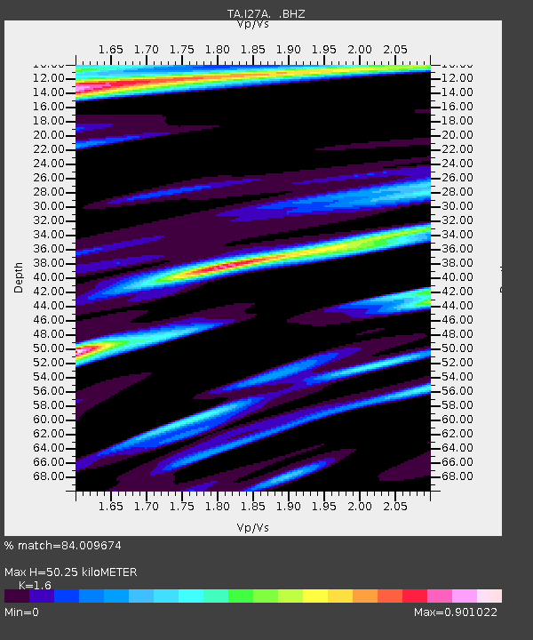
| Estimated Moho Depth: |
50.25 km |
| Estimated Crust Vp/Vs: |
1.60 |
| Assumed Crust Vp: |
6.242 km/s |
| Estimated Crust Vs: |
3.901 km/s |
| Estimated Crust Poisson's Ratio: |
0.18 |
|
| Radial Match: |
84.009674 % |
| Radial Bump: |
384 |
| Transverse Match: |
72.390274 % |
| Transverse Bump: |
400 |
| SOD ConfigId: |
2622 |
| Insert Time: |
2010-03-06 02:26:05.563 +0000 |
| GWidth: |
2.5 |
| Max Bumps: |
400 |
| Tol: |
0.001 |
|
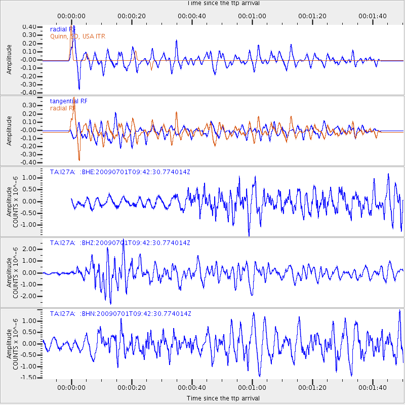
Signal To Noise
| Channel | StoN | STA | LTA |
| TA:I27A: :BHZ:20090701T09:42:30.774014Z | 3.7820458 | 2.588811E-7 | 6.8450014E-8 |
| TA:I27A: :BHN:20090701T09:42:30.774014Z | 0.91495013 | 1.9718844E-7 | 2.1551824E-7 |
| TA:I27A: :BHE:20090701T09:42:30.774014Z | 1.3405548 | 2.0233739E-7 | 1.5093555E-7 |
| Arrivals |
| Ps | 4.9 SECOND |
| PpPs | 20 SECOND |
| PsPs/PpSs | 25 SECOND |


