You are here: Home > Network List > TA - USArray Transportable Network (new EarthScope stations) Stations List
> Station O16K Kokwok River, Bristol Bay, AK, USA > Earthquake Result Viewer
O16K Kokwok River, Bristol Bay, AK, USA - Earthquake Result Viewer
| Earthquake location: |
Off East Coast Of Honshu, Japan |
| Earthquake latitude/longitude: |
36.3/143.7 |
| Earthquake time(UTC): |
2017/07/30 (211) 12:45:06 GMT |
| Earthquake Depth: |
17 km |
| Earthquake Magnitude: |
5.3 Mww |
| Earthquake Catalog/Contributor: |
NEIC PDE/us |
|
| Network: |
TA USArray Transportable Network (new EarthScope stations) |
| Station: |
O16K Kokwok River, Bristol Bay, AK, USA |
| Lat/Lon: |
59.59 N/158.09 W |
| Elevation: |
198 m |
|
| Distance: |
43.6 deg |
| Az: |
38.804 deg |
| Baz: |
264.45 deg |
| Ray Param: |
0.0724167 |
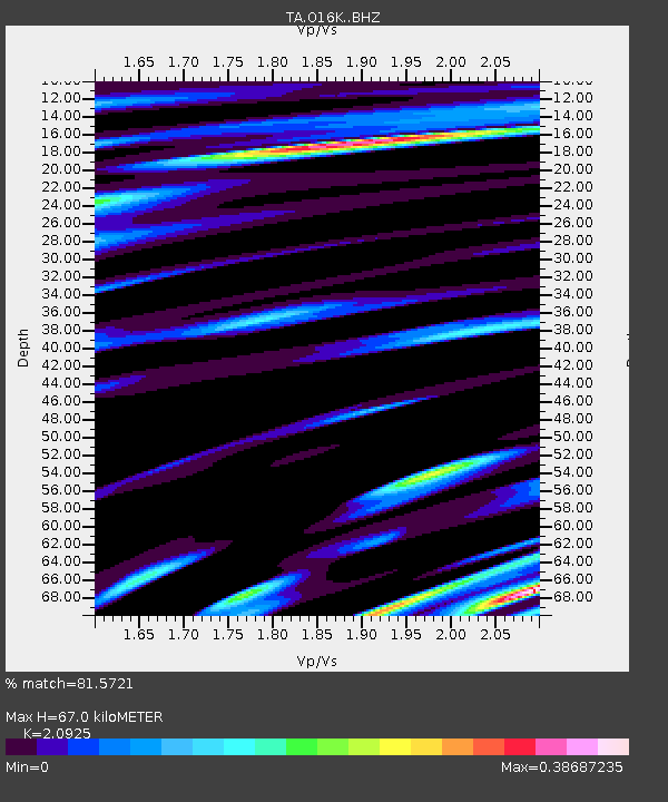
| Estimated Moho Depth: |
67.0 km |
| Estimated Crust Vp/Vs: |
2.09 |
| Assumed Crust Vp: |
6.24 km/s |
| Estimated Crust Vs: |
2.982 km/s |
| Estimated Crust Poisson's Ratio: |
0.35 |
|
| Radial Match: |
81.5721 % |
| Radial Bump: |
400 |
| Transverse Match: |
60.46789 % |
| Transverse Bump: |
400 |
| SOD ConfigId: |
13570011 |
| Insert Time: |
2019-04-28 12:17:08.126 +0000 |
| GWidth: |
2.5 |
| Max Bumps: |
400 |
| Tol: |
0.001 |
|

Signal To Noise
| Channel | StoN | STA | LTA |
| TA:O16K: :BHZ:20170730T12:52:39.049988Z | 8.568431 | 3.6472093E-7 | 4.2565663E-8 |
| TA:O16K: :BHN:20170730T12:52:39.049988Z | 0.9435336 | 5.975739E-8 | 6.333361E-8 |
| TA:O16K: :BHE:20170730T12:52:39.049988Z | 3.24243 | 1.5057822E-7 | 4.643993E-8 |
| Arrivals |
| Ps | 12 SECOND |
| PpPs | 32 SECOND |
| PsPs/PpSs | 44 SECOND |


