You are here: Home > Network List > TA - USArray Transportable Network (new EarthScope stations) Stations List
> Station I27A Quinn, SD, USA > Earthquake Result Viewer
I27A Quinn, SD, USA - Earthquake Result Viewer
| Earthquake location: |
Off Coast Of Costa Rica |
| Earthquake latitude/longitude: |
7.9/-85.6 |
| Earthquake time(UTC): |
2009/08/13 (225) 09:37:35 GMT |
| Earthquake Depth: |
10 km |
| Earthquake Magnitude: |
5.8 MW, 5.3 MB |
| Earthquake Catalog/Contributor: |
WHDF/NEIC |
|
| Network: |
TA USArray Transportable Network (new EarthScope stations) |
| Station: |
I27A Quinn, SD, USA |
| Lat/Lon: |
44.07 N/102.05 W |
| Elevation: |
867 m |
|
| Distance: |
38.7 deg |
| Az: |
340.994 deg |
| Baz: |
153.416 deg |
| Ray Param: |
0.07539258 |
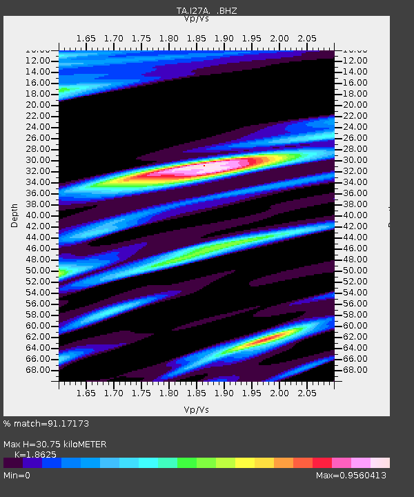
| Estimated Moho Depth: |
30.75 km |
| Estimated Crust Vp/Vs: |
1.86 |
| Assumed Crust Vp: |
6.242 km/s |
| Estimated Crust Vs: |
3.351 km/s |
| Estimated Crust Poisson's Ratio: |
0.30 |
|
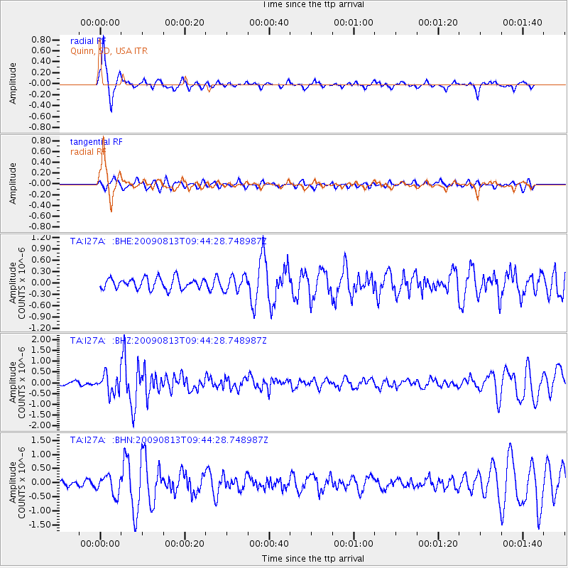
| Radial Match: |
91.17173 % |
| Radial Bump: |
280 |
| Transverse Match: |
62.0942 % |
| Transverse Bump: |
394 |
| SOD ConfigId: |
2622 |
| Insert Time: |
2010-03-06 02:26:10.111 +0000 |
| GWidth: |
2.5 |
| Max Bumps: |
400 |
| Tol: |
0.001 |
|
Signal To Noise
| Channel | StoN | STA | LTA |
| TA:I27A: :BHZ:20090813T09:44:28.748987Z | 4.4892545 | 4.3944078E-7 | 9.7887245E-8 |
| TA:I27A: :BHN:20090813T09:44:28.748987Z | 3.1698167 | 3.4018288E-7 | 1.07319416E-7 |
| TA:I27A: :BHE:20090813T09:44:28.748987Z | 1.3570976 | 1.9401054E-7 | 1.4295989E-7 |
| Arrivals |
| Ps | 4.5 SECOND |
| PpPs | 13 SECOND |
| PsPs/PpSs | 18 SECOND |


