You are here: Home > Network List > UU - University of Utah Regional Network Stations List
> Station FORU South Mineral Mountains, UT, USA > Earthquake Result Viewer
FORU South Mineral Mountains, UT, USA - Earthquake Result Viewer
*The percent match for this event was below the threshold and hence no stack was calculated.
| Earthquake location: |
Hokkaido, Japan Region |
| Earthquake latitude/longitude: |
42.0/142.7 |
| Earthquake time(UTC): |
2016/01/14 (014) 03:25:34 GMT |
| Earthquake Depth: |
51 km |
| Earthquake Magnitude: |
6.7 MWP, 6.7 MI |
| Earthquake Catalog/Contributor: |
NEIC PDE/NEIC COMCAT |
|
| Network: |
UU University of Utah Regional Network |
| Station: |
FORU South Mineral Mountains, UT, USA |
| Lat/Lon: |
38.46 N/112.86 W |
| Elevation: |
1840 m |
|
| Distance: |
74.5 deg |
| Az: |
52.086 deg |
| Baz: |
311.445 deg |
| Ray Param: |
$rayparam |
*The percent match for this event was below the threshold and hence was not used in the summary stack. |
|
| Radial Match: |
69.06434 % |
| Radial Bump: |
400 |
| Transverse Match: |
67.60139 % |
| Transverse Bump: |
400 |
| SOD ConfigId: |
1399611 |
| Insert Time: |
2016-01-28 04:40:59.156 +0000 |
| GWidth: |
2.5 |
| Max Bumps: |
400 |
| Tol: |
0.001 |
|
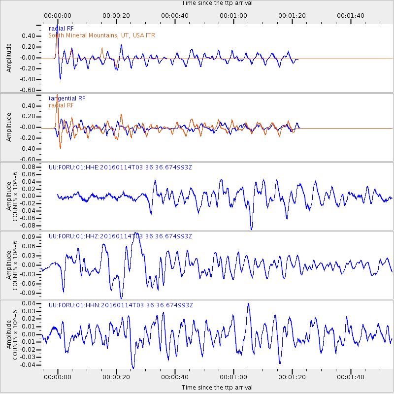
Signal To Noise
| Channel | StoN | STA | LTA |
| UU:FORU:01:HHZ:20160114T03:36:36.674993Z | 4.7908196 | 3.2748623E-8 | 6.8357036E-9 |
| UU:FORU:01:HHN:20160114T03:36:36.674993Z | 2.9502022 | 1.2639677E-8 | 4.2843427E-9 |
| UU:FORU:01:HHE:20160114T03:36:36.674993Z | 4.223335 | 2.2400211E-8 | 5.3039155E-9 |
| Arrivals |
| Ps | |
| PpPs | |
| PsPs/PpSs | |


