You are here: Home > Network List > TJ - Tajikistan National Seismic Network Stations List
> Station GARM Garm, Tajikistan > Earthquake Result Viewer
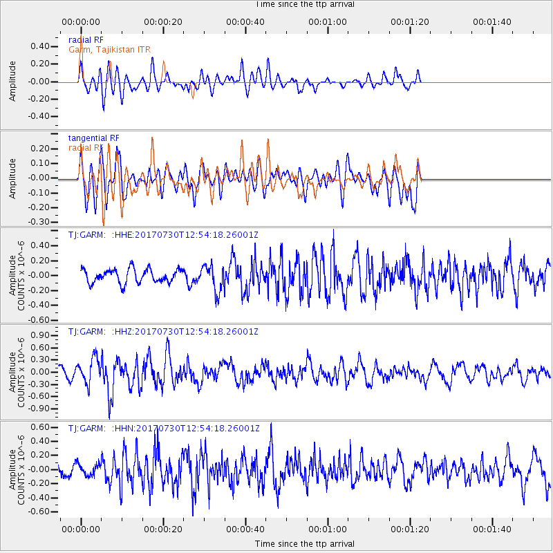
GARM Garm, Tajikistan - Earthquake Result Viewer
*The percent match for this event was below the threshold and hence no stack was calculated.
| Earthquake location: |
Off East Coast Of Honshu, Japan |
| Earthquake latitude/longitude: |
36.3/143.7 |
| Earthquake time(UTC): |
2017/07/30 (211) 12:45:06 GMT |
| Earthquake Depth: |
17 km |
| Earthquake Magnitude: |
5.3 Mww |
| Earthquake Catalog/Contributor: |
NEIC PDE/us |
|
| Network: |
TJ Tajikistan National Seismic Network |
| Station: |
GARM Garm, Tajikistan |
| Lat/Lon: |
39.00 N/70.32 E |
| Elevation: |
1305 m |
|
| Distance: |
56.7 deg |
| Az: |
296.671 deg |
| Baz: |
67.894 deg |
| Ray Param: |
$rayparam |
*The percent match for this event was below the threshold and hence was not used in the summary stack. |
|
| Radial Match: |
64.87172 % |
| Radial Bump: |
400 |
| Transverse Match: |
61.61907 % |
| Transverse Bump: |
400 |
| SOD ConfigId: |
13570011 |
| Insert Time: |
2019-04-28 12:17:38.019 +0000 |
| GWidth: |
2.5 |
| Max Bumps: |
400 |
| Tol: |
0.001 |
|
Signal To Noise
| Channel | StoN | STA | LTA |
| TJ:GARM: :HHZ:20170730T12:54:18.26001Z | 1.4985229 | 3.1840892E-7 | 2.1248186E-7 |
| TJ:GARM: :HHN:20170730T12:54:18.26001Z | 0.5712689 | 7.7390425E-8 | 1.354711E-7 |
| TJ:GARM: :HHE:20170730T12:54:18.26001Z | 1.9175994 | 1.7632611E-7 | 9.1951485E-8 |
| Arrivals |
| Ps | |
| PpPs | |
| PsPs/PpSs | |


