You are here: Home > Network List > TA - USArray Transportable Network (new EarthScope stations) Stations List
> Station I27A Quinn, SD, USA > Earthquake Result Viewer
I27A Quinn, SD, USA - Earthquake Result Viewer

| Earthquake location: |
Near Coast Of Venezuela |
| Earthquake latitude/longitude: |
10.7/-67.9 |
| Earthquake time(UTC): |
2009/09/12 (255) 20:06:24 GMT |
| Earthquake Depth: |
10 km |
| Earthquake Magnitude: |
6.3 MB, 6.4 MS, 6.3 MW, 6.3 MW |
| Earthquake Catalog/Contributor: |
WHDF/NEIC |
|
| Network: |
TA USArray Transportable Network (new EarthScope stations) |
| Station: |
I27A Quinn, SD, USA |
| Lat/Lon: |
44.07 N/102.05 W |
| Elevation: |
867 m |
|
| Distance: |
44.4 deg |
| Az: |
324.692 deg |
| Baz: |
127.998 deg |
| Ray Param: |
0.0719327 |
| Estimated Moho Depth: |
48.5 km |
| Estimated Crust Vp/Vs: |
1.79 |
| Assumed Crust Vp: |
6.242 km/s |
| Estimated Crust Vs: |
3.497 km/s |
| Estimated Crust Poisson's Ratio: |
0.27 |
|
| Radial Match: |
85.78461 % |
| Radial Bump: |
261 |
| Transverse Match: |
60.805897 % |
| Transverse Bump: |
358 |
| SOD ConfigId: |
2622 |
| Insert Time: |
2010-03-06 02:26:17.821 +0000 |
| GWidth: |
2.5 |
| Max Bumps: |
400 |
| Tol: |
0.001 |
|
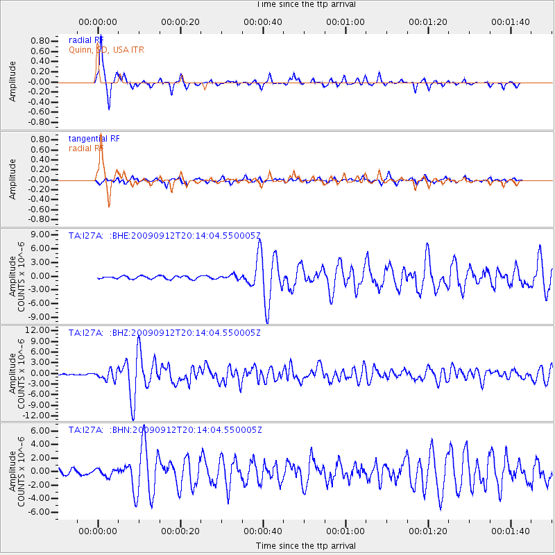
Signal To Noise
| Channel | StoN | STA | LTA |
| TA:I27A: :BHZ:20090912T20:14:04.550005Z | 7.9234986 | 1.3250944E-6 | 1.6723602E-7 |
| TA:I27A: :BHN:20090912T20:14:04.550005Z | 1.5499035 | 5.439515E-7 | 3.509583E-7 |
| TA:I27A: :BHE:20090912T20:14:04.550005Z | 1.3969164 | 4.3544907E-7 | 3.1172164E-7 |
| Arrivals |
| Ps | 6.5 SECOND |
| PpPs | 20 SECOND |
| PsPs/PpSs | 27 SECOND |


