You are here: Home > Network List > TA - USArray Transportable Network (new EarthScope stations) Stations List
> Station I27A Quinn, SD, USA > Earthquake Result Viewer
I27A Quinn, SD, USA - Earthquake Result Viewer

| Earthquake location: |
Baffin Bay |
| Earthquake latitude/longitude: |
75.4/-72.5 |
| Earthquake time(UTC): |
2009/07/07 (188) 19:11:46 GMT |
| Earthquake Depth: |
19 km |
| Earthquake Magnitude: |
5.9 MB, 5.7 MS, 6.1 MW, 6.0 MW |
| Earthquake Catalog/Contributor: |
WHDF/NEIC |
|
| Network: |
TA USArray Transportable Network (new EarthScope stations) |
| Station: |
I27A Quinn, SD, USA |
| Lat/Lon: |
44.07 N/102.05 W |
| Elevation: |
867 m |
|
| Distance: |
33.9 deg |
| Az: |
219.642 deg |
| Baz: |
13.017 deg |
| Ray Param: |
0.07796551 |
| Estimated Moho Depth: |
15.75 km |
| Estimated Crust Vp/Vs: |
1.61 |
| Assumed Crust Vp: |
6.242 km/s |
| Estimated Crust Vs: |
3.883 km/s |
| Estimated Crust Poisson's Ratio: |
0.18 |
|
| Radial Match: |
87.95369 % |
| Radial Bump: |
331 |
| Transverse Match: |
72.04429 % |
| Transverse Bump: |
400 |
| SOD ConfigId: |
2648 |
| Insert Time: |
2010-03-06 02:26:20.754 +0000 |
| GWidth: |
2.5 |
| Max Bumps: |
400 |
| Tol: |
0.001 |
|
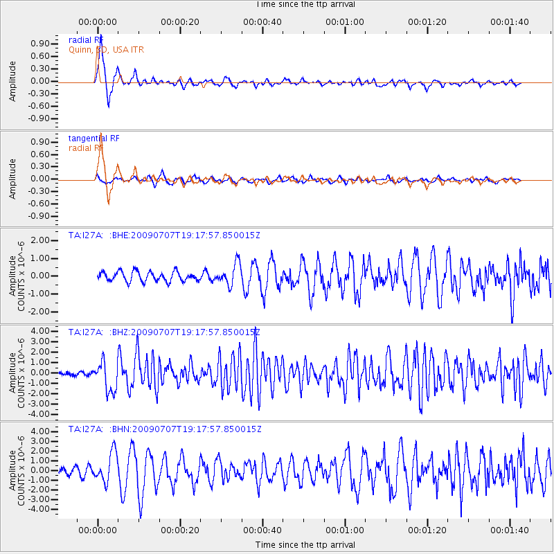
Signal To Noise
| Channel | StoN | STA | LTA |
| TA:I27A: :BHZ:20090707T19:17:57.850015Z | 10.603767 | 1.4660213E-6 | 1.3825476E-7 |
| TA:I27A: :BHN:20090707T19:17:57.850015Z | 2.9456985 | 1.5689809E-6 | 5.326346E-7 |
| TA:I27A: :BHE:20090707T19:17:57.850015Z | 2.304956 | 6.2144613E-7 | 2.6961303E-7 |
| Arrivals |
| Ps | 1.7 SECOND |
| PpPs | 6.1 SECOND |
| PsPs/PpSs | 7.7 SECOND |


