You are here: Home > Network List > TA - USArray Transportable Network (new EarthScope stations) Stations List
> Station I27A Quinn, SD, USA > Earthquake Result Viewer
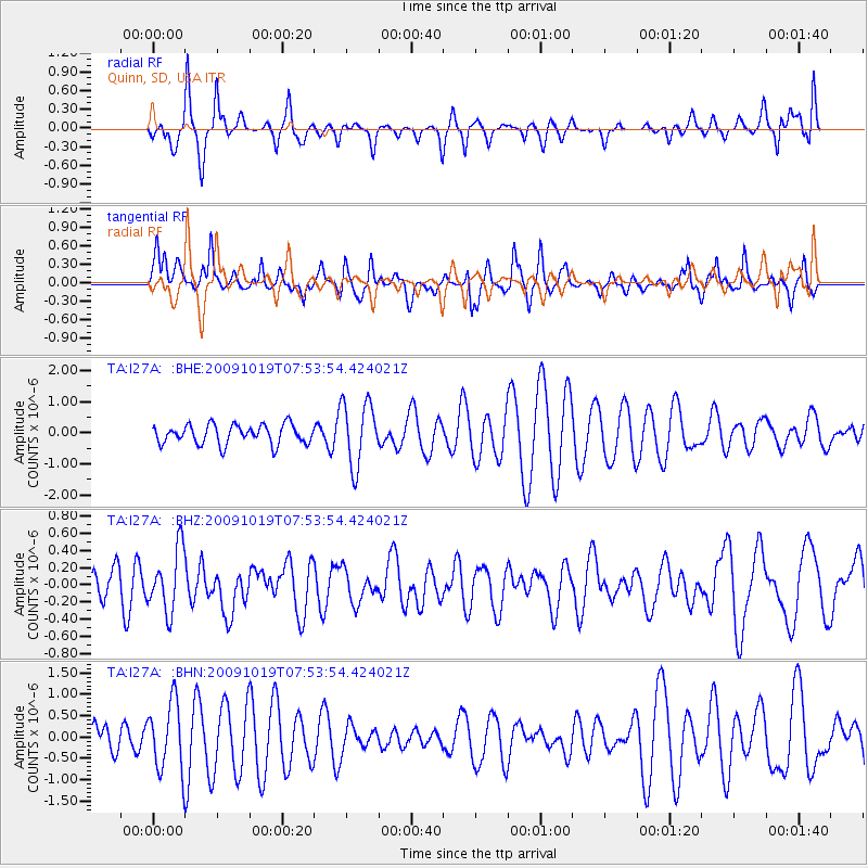
I27A Quinn, SD, USA - Earthquake Result Viewer
*The percent match for this event was below the threshold and hence no stack was calculated.
| Earthquake location: |
Samoa Islands Region |
| Earthquake latitude/longitude: |
-15.4/-173.0 |
| Earthquake time(UTC): |
2009/10/19 (292) 07:41:38 GMT |
| Earthquake Depth: |
10 km |
| Earthquake Magnitude: |
5.8 MW, 5.4 MS, 5.4 MB, 5.8 MW |
| Earthquake Catalog/Contributor: |
WHDF/NEIC |
|
| Network: |
TA USArray Transportable Network (new EarthScope stations) |
| Station: |
I27A Quinn, SD, USA |
| Lat/Lon: |
44.07 N/102.05 W |
| Elevation: |
867 m |
|
| Distance: |
87.5 deg |
| Az: |
42.993 deg |
| Baz: |
245.825 deg |
| Ray Param: |
$rayparam |
*The percent match for this event was below the threshold and hence was not used in the summary stack. |
|
| Radial Match: |
53.212734 % |
| Radial Bump: |
299 |
| Transverse Match: |
61.916725 % |
| Transverse Bump: |
338 |
| SOD ConfigId: |
2622 |
| Insert Time: |
2010-03-06 02:26:34.977 +0000 |
| GWidth: |
2.5 |
| Max Bumps: |
400 |
| Tol: |
0.001 |
|
Signal To Noise
| Channel | StoN | STA | LTA |
| TA:I27A: :BHZ:20091019T07:53:54.424021Z | 2.1890793 | 3.5957711E-7 | 1.6425952E-7 |
| TA:I27A: :BHN:20091019T07:53:54.424021Z | 1.1351925 | 7.8981736E-7 | 6.957563E-7 |
| TA:I27A: :BHE:20091019T07:53:54.424021Z | 3.3255484 | 1.0259528E-6 | 3.0850634E-7 |
| Arrivals |
| Ps | |
| PpPs | |
| PsPs/PpSs | |


