You are here: Home > Network List > TA - USArray Transportable Network (new EarthScope stations) Stations List
> Station I26A New Underwood, SD, USA > Earthquake Result Viewer
I26A New Underwood, SD, USA - Earthquake Result Viewer
| Earthquake location: |
Off Coast Of Costa Rica |
| Earthquake latitude/longitude: |
7.9/-85.6 |
| Earthquake time(UTC): |
2009/08/13 (225) 09:37:35 GMT |
| Earthquake Depth: |
10 km |
| Earthquake Magnitude: |
5.8 MW, 5.3 MB |
| Earthquake Catalog/Contributor: |
WHDF/NEIC |
|
| Network: |
TA USArray Transportable Network (new EarthScope stations) |
| Station: |
I26A New Underwood, SD, USA |
| Lat/Lon: |
44.03 N/102.86 W |
| Elevation: |
971 m |
|
| Distance: |
39.0 deg |
| Az: |
340.141 deg |
| Baz: |
152.193 deg |
| Ray Param: |
0.075258516 |
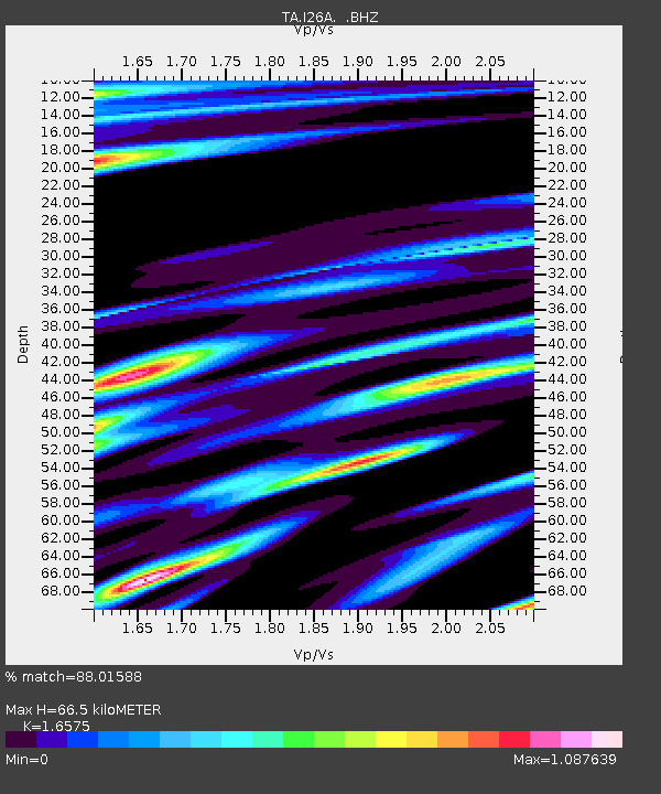
| Estimated Moho Depth: |
66.5 km |
| Estimated Crust Vp/Vs: |
1.66 |
| Assumed Crust Vp: |
6.242 km/s |
| Estimated Crust Vs: |
3.766 km/s |
| Estimated Crust Poisson's Ratio: |
0.21 |
|
| Radial Match: |
88.01588 % |
| Radial Bump: |
305 |
| Transverse Match: |
37.60314 % |
| Transverse Bump: |
400 |
| SOD ConfigId: |
2622 |
| Insert Time: |
2010-03-06 02:26:44.166 +0000 |
| GWidth: |
2.5 |
| Max Bumps: |
400 |
| Tol: |
0.001 |
|

Signal To Noise
| Channel | StoN | STA | LTA |
| TA:I26A: :BHZ:20090813T09:44:30.675012Z | 3.2322044 | 2.9297968E-7 | 9.064392E-8 |
| TA:I26A: :BHN:20090813T09:44:30.675012Z | 1.3375192 | 2.277185E-7 | 1.7025438E-7 |
| TA:I26A: :BHE:20090813T09:44:30.675012Z | 1.1265815 | 1.9135118E-7 | 1.6985116E-7 |
| Arrivals |
| Ps | 7.5 SECOND |
| PpPs | 26 SECOND |
| PsPs/PpSs | 34 SECOND |


