You are here: Home > Network List > TA - USArray Transportable Network (new EarthScope stations) Stations List
> Station I26A New Underwood, SD, USA > Earthquake Result Viewer
I26A New Underwood, SD, USA - Earthquake Result Viewer
| Earthquake location: |
Samoa Islands Region |
| Earthquake latitude/longitude: |
-15.5/-172.1 |
| Earthquake time(UTC): |
2009/09/29 (272) 17:48:10 GMT |
| Earthquake Depth: |
18 km |
| Earthquake Magnitude: |
7.1 MB, 8.1 MS, 8.1 MW, 8.0 MW |
| Earthquake Catalog/Contributor: |
WHDF/NEIC |
|
| Network: |
TA USArray Transportable Network (new EarthScope stations) |
| Station: |
I26A New Underwood, SD, USA |
| Lat/Lon: |
44.03 N/102.86 W |
| Elevation: |
971 m |
|
| Distance: |
86.4 deg |
| Az: |
42.514 deg |
| Baz: |
244.594 deg |
| Ray Param: |
0.04406304 |
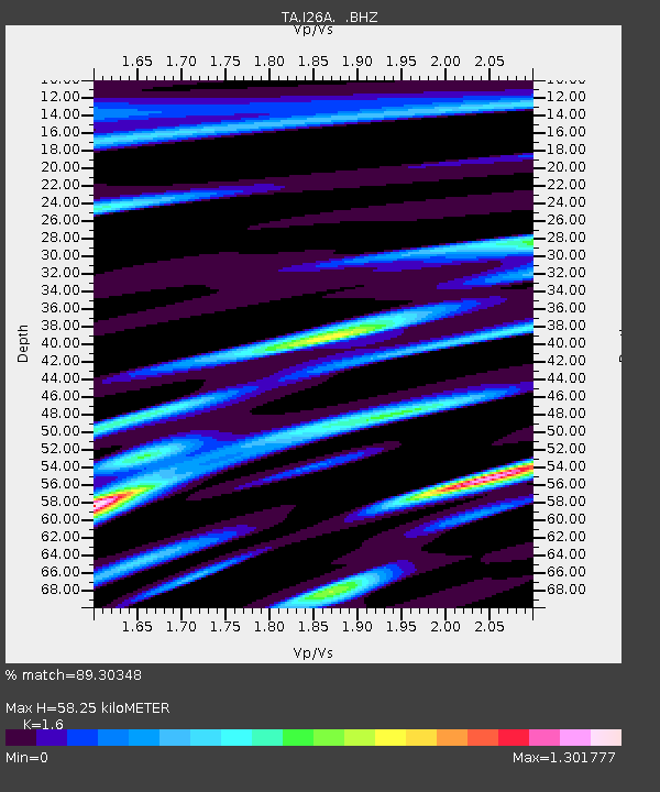
| Estimated Moho Depth: |
58.25 km |
| Estimated Crust Vp/Vs: |
1.60 |
| Assumed Crust Vp: |
6.242 km/s |
| Estimated Crust Vs: |
3.901 km/s |
| Estimated Crust Poisson's Ratio: |
0.18 |
|
| Radial Match: |
89.30348 % |
| Radial Bump: |
400 |
| Transverse Match: |
70.77464 % |
| Transverse Bump: |
400 |
| SOD ConfigId: |
2622 |
| Insert Time: |
2010-03-06 02:26:47.968 +0000 |
| GWidth: |
2.5 |
| Max Bumps: |
400 |
| Tol: |
0.001 |
|

Signal To Noise
| Channel | StoN | STA | LTA |
| TA:I26A: :BHZ:20090929T18:00:20.674021Z | 13.837603 | 2.8295044E-6 | 2.0447938E-7 |
| TA:I26A: :BHN:20090929T18:00:20.674021Z | 0.8768084 | 4.7531384E-7 | 5.420954E-7 |
| TA:I26A: :BHE:20090929T18:00:20.674021Z | 2.9021647 | 9.799539E-7 | 3.3766312E-7 |
| Arrivals |
| Ps | 5.7 SECOND |
| PpPs | 24 SECOND |
| PsPs/PpSs | 29 SECOND |


