You are here: Home > Network List > AZ - ANZA Regional Network Stations List
> Station FRD AZ.FRD > Earthquake Result Viewer
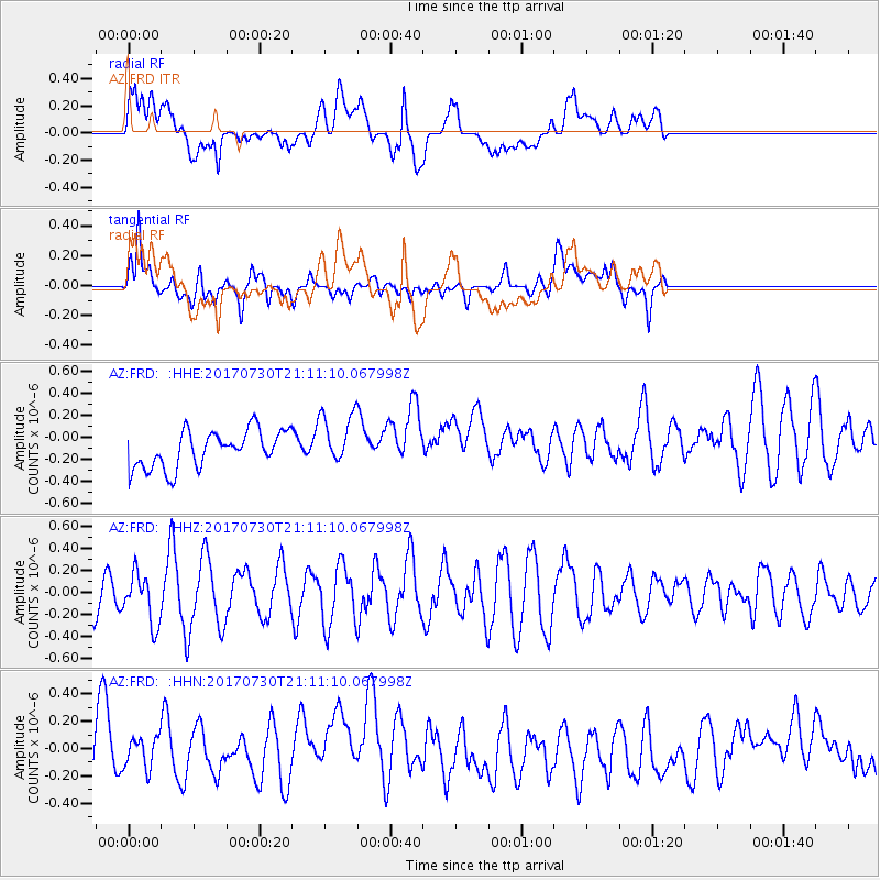
FRD AZ.FRD - Earthquake Result Viewer
*The percent match for this event was below the threshold and hence no stack was calculated.
| Earthquake location: |
Kuril Islands |
| Earthquake latitude/longitude: |
46.2/151.0 |
| Earthquake time(UTC): |
2017/07/30 (211) 21:00:49 GMT |
| Earthquake Depth: |
87 km |
| Earthquake Magnitude: |
5.7 mb |
| Earthquake Catalog/Contributor: |
NEIC PDE/us |
|
| Network: |
AZ ANZA Regional Network |
| Station: |
FRD AZ.FRD |
| Lat/Lon: |
33.49 N/116.60 W |
| Elevation: |
1164 m |
|
| Distance: |
68.3 deg |
| Az: |
64.006 deg |
| Baz: |
311.673 deg |
| Ray Param: |
$rayparam |
*The percent match for this event was below the threshold and hence was not used in the summary stack. |
|
| Radial Match: |
49.082 % |
| Radial Bump: |
400 |
| Transverse Match: |
60.393185 % |
| Transverse Bump: |
400 |
| SOD ConfigId: |
13570011 |
| Insert Time: |
2019-04-28 12:21:15.782 +0000 |
| GWidth: |
2.5 |
| Max Bumps: |
400 |
| Tol: |
0.001 |
|
Signal To Noise
| Channel | StoN | STA | LTA |
| AZ:FRD: :HHZ:20170730T21:11:10.067998Z | 0.9558277 | 2.2623294E-7 | 2.3668798E-7 |
| AZ:FRD: :HHN:20170730T21:11:10.067998Z | 0.48676684 | 1.3715238E-7 | 2.8176197E-7 |
| AZ:FRD: :HHE:20170730T21:11:10.067998Z | 1.4259374 | 2.4106387E-7 | 1.6905642E-7 |
| Arrivals |
| Ps | |
| PpPs | |
| PsPs/PpSs | |


