You are here: Home > Network List > TA - USArray Transportable Network (new EarthScope stations) Stations List
> Station I26A New Underwood, SD, USA > Earthquake Result Viewer
I26A New Underwood, SD, USA - Earthquake Result Viewer
| Earthquake location: |
East Of Severnaya Zemlya |
| Earthquake latitude/longitude: |
81.6/119.5 |
| Earthquake time(UTC): |
2009/10/07 (280) 20:52:13 GMT |
| Earthquake Depth: |
8.0 km |
| Earthquake Magnitude: |
5.7 MB, 5.1 MS, 5.8 MW, 5.8 MW |
| Earthquake Catalog/Contributor: |
WHDF/NEIC |
|
| Network: |
TA USArray Transportable Network (new EarthScope stations) |
| Station: |
I26A New Underwood, SD, USA |
| Lat/Lon: |
44.03 N/102.86 W |
| Elevation: |
971 m |
|
| Distance: |
52.7 deg |
| Az: |
37.706 deg |
| Baz: |
352.814 deg |
| Ray Param: |
0.066618346 |
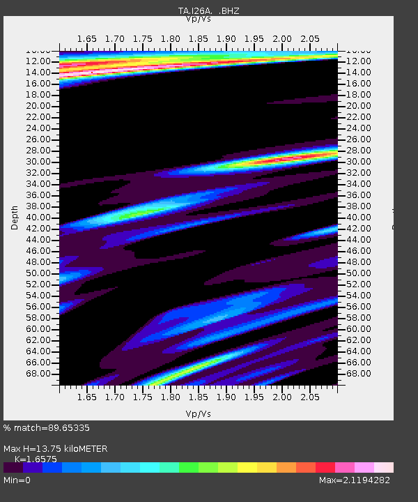
| Estimated Moho Depth: |
13.75 km |
| Estimated Crust Vp/Vs: |
1.66 |
| Assumed Crust Vp: |
6.242 km/s |
| Estimated Crust Vs: |
3.766 km/s |
| Estimated Crust Poisson's Ratio: |
0.21 |
|
| Radial Match: |
89.65335 % |
| Radial Bump: |
400 |
| Transverse Match: |
82.13432 % |
| Transverse Bump: |
400 |
| SOD ConfigId: |
2622 |
| Insert Time: |
2010-03-06 02:26:49.090 +0000 |
| GWidth: |
2.5 |
| Max Bumps: |
400 |
| Tol: |
0.001 |
|

Signal To Noise
| Channel | StoN | STA | LTA |
| TA:I26A: :BHZ:20091007T21:00:56.675029Z | 5.3551855 | 8.818697E-7 | 1.6467584E-7 |
| TA:I26A: :BHN:20091007T21:00:56.675029Z | 1.5218233 | 6.555172E-7 | 4.3074462E-7 |
| TA:I26A: :BHE:20091007T21:00:56.675029Z | 1.5703082 | 4.485068E-7 | 2.8561706E-7 |
| Arrivals |
| Ps | 1.5 SECOND |
| PpPs | 5.5 SECOND |
| PsPs/PpSs | 7.1 SECOND |


