You are here: Home > Network List > CI - Caltech Regional Seismic Network Stations List
> Station SMM Simmler, CA, USA > Earthquake Result Viewer
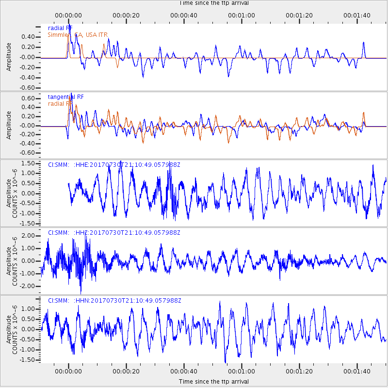
SMM Simmler, CA, USA - Earthquake Result Viewer
*The percent match for this event was below the threshold and hence no stack was calculated.
| Earthquake location: |
Kuril Islands |
| Earthquake latitude/longitude: |
46.2/151.0 |
| Earthquake time(UTC): |
2017/07/30 (211) 21:00:49 GMT |
| Earthquake Depth: |
87 km |
| Earthquake Magnitude: |
5.7 mb |
| Earthquake Catalog/Contributor: |
NEIC PDE/us |
|
| Network: |
CI Caltech Regional Seismic Network |
| Station: |
SMM Simmler, CA, USA |
| Lat/Lon: |
35.31 N/120.00 W |
| Elevation: |
599 m |
|
| Distance: |
64.9 deg |
| Az: |
64.508 deg |
| Baz: |
309.963 deg |
| Ray Param: |
$rayparam |
*The percent match for this event was below the threshold and hence was not used in the summary stack. |
|
| Radial Match: |
48.39751 % |
| Radial Bump: |
400 |
| Transverse Match: |
69.65139 % |
| Transverse Bump: |
400 |
| SOD ConfigId: |
13570011 |
| Insert Time: |
2019-04-28 12:22:18.468 +0000 |
| GWidth: |
2.5 |
| Max Bumps: |
400 |
| Tol: |
0.001 |
|
Signal To Noise
| Channel | StoN | STA | LTA |
| CI:SMM: :HHZ:20170730T21:10:49.057988Z | 1.8714874 | 8.7495465E-7 | 4.6751833E-7 |
| CI:SMM: :HHN:20170730T21:10:49.057988Z | 1.5726177 | 6.057498E-7 | 3.8518567E-7 |
| CI:SMM: :HHE:20170730T21:10:49.057988Z | 0.91838694 | 5.731948E-7 | 6.2413216E-7 |
| Arrivals |
| Ps | |
| PpPs | |
| PsPs/PpSs | |


