You are here: Home > Network List > LD - Lamont-Doherty Cooperative Seismographic Network Stations List
> Station MVL Millersville University, PA > Earthquake Result Viewer
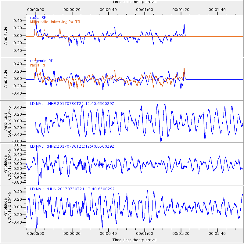
MVL Millersville University, PA - Earthquake Result Viewer
*The percent match for this event was below the threshold and hence no stack was calculated.
| Earthquake location: |
Kuril Islands |
| Earthquake latitude/longitude: |
46.2/151.0 |
| Earthquake time(UTC): |
2017/07/30 (211) 21:00:49 GMT |
| Earthquake Depth: |
87 km |
| Earthquake Magnitude: |
5.7 mb |
| Earthquake Catalog/Contributor: |
NEIC PDE/us |
|
| Network: |
LD Lamont-Doherty Cooperative Seismographic Network |
| Station: |
MVL Millersville University, PA |
| Lat/Lon: |
40.00 N/76.35 W |
| Elevation: |
91 m |
|
| Distance: |
84.3 deg |
| Az: |
34.566 deg |
| Baz: |
329.143 deg |
| Ray Param: |
$rayparam |
*The percent match for this event was below the threshold and hence was not used in the summary stack. |
|
| Radial Match: |
45.232452 % |
| Radial Bump: |
386 |
| Transverse Match: |
48.479702 % |
| Transverse Bump: |
326 |
| SOD ConfigId: |
13570011 |
| Insert Time: |
2019-04-28 12:25:22.168 +0000 |
| GWidth: |
2.5 |
| Max Bumps: |
400 |
| Tol: |
0.001 |
|
Signal To Noise
| Channel | StoN | STA | LTA |
| LD:MVL: :HHZ:20170730T21:12:40.650029Z | 2.3248298 | 4.0108438E-7 | 1.7252204E-7 |
| LD:MVL: :HHN:20170730T21:12:40.650029Z | 1.3473265 | 2.5697028E-7 | 1.9072606E-7 |
| LD:MVL: :HHE:20170730T21:12:40.650029Z | 1.4645352 | 2.8363024E-7 | 1.936657E-7 |
| Arrivals |
| Ps | |
| PpPs | |
| PsPs/PpSs | |


