You are here: Home > Network List > TA - USArray Transportable Network (new EarthScope stations) Stations List
> Station Y23A Lovelace Mesa, Carrizozo, NM, USA > Earthquake Result Viewer
Y23A Lovelace Mesa, Carrizozo, NM, USA - Earthquake Result Viewer

| Earthquake location: |
Southern Peru |
| Earthquake latitude/longitude: |
-16.0/-71.7 |
| Earthquake time(UTC): |
2008/07/08 (190) 09:13:07 GMT |
| Earthquake Depth: |
123 km |
| Earthquake Magnitude: |
5.8 MB, 6.2 MW, 6.2 MW |
| Earthquake Catalog/Contributor: |
WHDF/NEIC |
|
| Network: |
TA USArray Transportable Network (new EarthScope stations) |
| Station: |
Y23A Lovelace Mesa, Carrizozo, NM, USA |
| Lat/Lon: |
33.93 N/106.05 W |
| Elevation: |
1789 m |
|
| Distance: |
59.4 deg |
| Az: |
327.028 deg |
| Baz: |
140.981 deg |
| Ray Param: |
0.061821453 |
| Estimated Moho Depth: |
39.25 km |
| Estimated Crust Vp/Vs: |
1.81 |
| Assumed Crust Vp: |
6.502 km/s |
| Estimated Crust Vs: |
3.602 km/s |
| Estimated Crust Poisson's Ratio: |
0.28 |
|
| Radial Match: |
83.982506 % |
| Radial Bump: |
400 |
| Transverse Match: |
69.25969 % |
| Transverse Bump: |
400 |
| SOD ConfigId: |
2504 |
| Insert Time: |
2010-03-06 02:27:29.007 +0000 |
| GWidth: |
2.5 |
| Max Bumps: |
400 |
| Tol: |
0.001 |
|
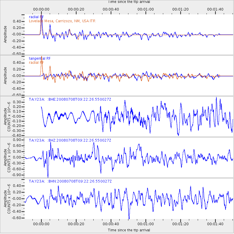
Signal To Noise
| Channel | StoN | STA | LTA |
| TA:Y23A: :BHZ:20080708T09:22:26.550027Z | 3.7317457 | 3.5331513E-7 | 9.467824E-8 |
| TA:Y23A: :BHN:20080708T09:22:26.550027Z | 1.7490805 | 1.5963394E-7 | 9.126735E-8 |
| TA:Y23A: :BHE:20080708T09:22:26.550027Z | 1.1951293 | 9.7947584E-8 | 8.195564E-8 |
| Arrivals |
| Ps | 5.1 SECOND |
| PpPs | 16 SECOND |
| PsPs/PpSs | 21 SECOND |


