You are here: Home > Network List > TA - USArray Transportable Network (new EarthScope stations) Stations List
> Station Y23A Lovelace Mesa, Carrizozo, NM, USA > Earthquake Result Viewer
Y23A Lovelace Mesa, Carrizozo, NM, USA - Earthquake Result Viewer

| Earthquake location: |
Near S. Coast Of Honshu, Japan |
| Earthquake latitude/longitude: |
33.2/137.9 |
| Earthquake time(UTC): |
2009/08/09 (221) 10:55:55 GMT |
| Earthquake Depth: |
297 km |
| Earthquake Magnitude: |
6.5 MB, 7.1 MW, 7.1 MW |
| Earthquake Catalog/Contributor: |
WHDF/NEIC |
|
| Network: |
TA USArray Transportable Network (new EarthScope stations) |
| Station: |
Y23A Lovelace Mesa, Carrizozo, NM, USA |
| Lat/Lon: |
33.93 N/106.05 W |
| Elevation: |
1789 m |
|
| Distance: |
90.2 deg |
| Az: |
48.354 deg |
| Baz: |
311.075 deg |
| Ray Param: |
0.04162226 |
| Estimated Moho Depth: |
36.25 km |
| Estimated Crust Vp/Vs: |
1.88 |
| Assumed Crust Vp: |
6.502 km/s |
| Estimated Crust Vs: |
3.458 km/s |
| Estimated Crust Poisson's Ratio: |
0.30 |
|
| Radial Match: |
93.898926 % |
| Radial Bump: |
400 |
| Transverse Match: |
75.65106 % |
| Transverse Bump: |
400 |
| SOD ConfigId: |
2622 |
| Insert Time: |
2010-03-06 02:27:51.955 +0000 |
| GWidth: |
2.5 |
| Max Bumps: |
400 |
| Tol: |
0.001 |
|
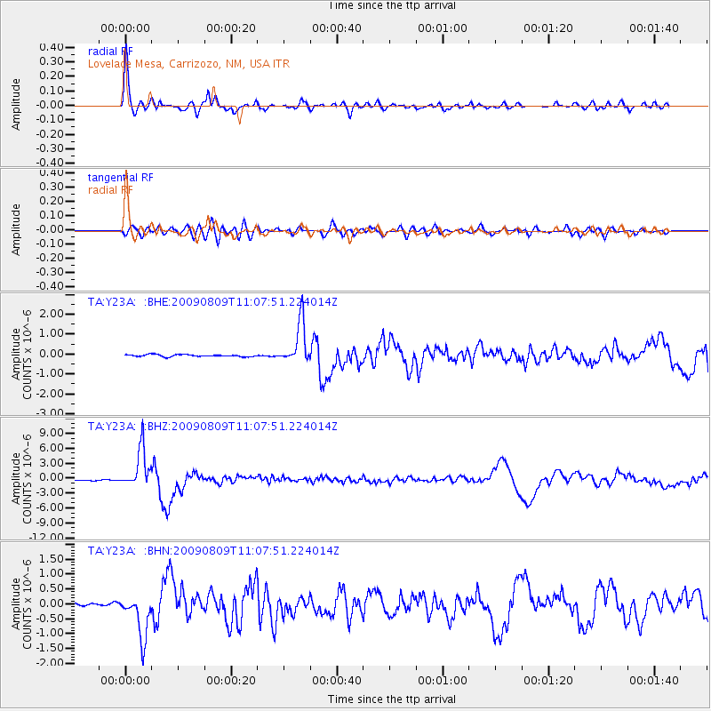
Signal To Noise
| Channel | StoN | STA | LTA |
| TA:Y23A: :BHZ:20090809T11:07:51.224014Z | 46.21138 | 4.0354944E-6 | 8.732686E-8 |
| TA:Y23A: :BHN:20090809T11:07:51.224014Z | 16.125532 | 7.440775E-7 | 4.614282E-8 |
| TA:Y23A: :BHE:20090809T11:07:51.224014Z | 20.945004 | 1.0845532E-6 | 5.1781E-8 |
| Arrivals |
| Ps | 5.0 SECOND |
| PpPs | 16 SECOND |
| PsPs/PpSs | 21 SECOND |


