You are here: Home > Network List > TA - USArray Transportable Network (new EarthScope stations) Stations List
> Station Y23A Lovelace Mesa, Carrizozo, NM, USA > Earthquake Result Viewer
Y23A Lovelace Mesa, Carrizozo, NM, USA - Earthquake Result Viewer

| Earthquake location: |
Southeast Of Honshu, Japan |
| Earthquake latitude/longitude: |
32.8/140.4 |
| Earthquake time(UTC): |
2009/08/12 (224) 22:48:51 GMT |
| Earthquake Depth: |
53 km |
| Earthquake Magnitude: |
6.2 MB, 6.6 MW, 6.6 MW |
| Earthquake Catalog/Contributor: |
WHDF/NEIC |
|
| Network: |
TA USArray Transportable Network (new EarthScope stations) |
| Station: |
Y23A Lovelace Mesa, Carrizozo, NM, USA |
| Lat/Lon: |
33.93 N/106.05 W |
| Elevation: |
1789 m |
|
| Distance: |
88.9 deg |
| Az: |
49.671 deg |
| Baz: |
309.462 deg |
| Ray Param: |
0.04218805 |
| Estimated Moho Depth: |
40.5 km |
| Estimated Crust Vp/Vs: |
1.82 |
| Assumed Crust Vp: |
6.502 km/s |
| Estimated Crust Vs: |
3.582 km/s |
| Estimated Crust Poisson's Ratio: |
0.28 |
|
| Radial Match: |
92.75253 % |
| Radial Bump: |
295 |
| Transverse Match: |
79.74351 % |
| Transverse Bump: |
400 |
| SOD ConfigId: |
2622 |
| Insert Time: |
2010-03-06 02:27:53.822 +0000 |
| GWidth: |
2.5 |
| Max Bumps: |
400 |
| Tol: |
0.001 |
|
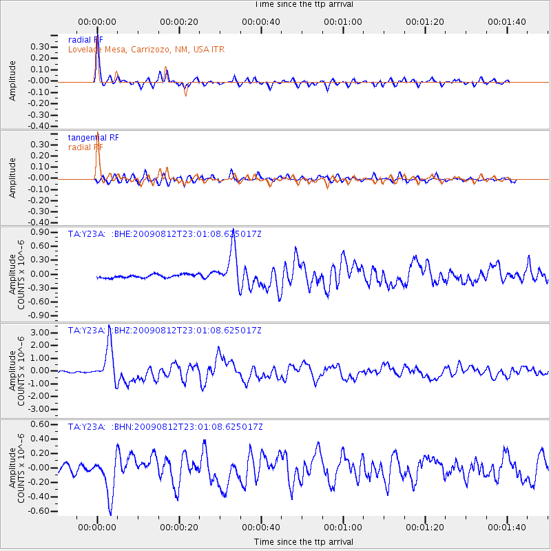
Signal To Noise
| Channel | StoN | STA | LTA |
| TA:Y23A: :BHZ:20090812T23:01:08.625017Z | 23.585066 | 1.489519E-6 | 6.315518E-8 |
| TA:Y23A: :BHN:20090812T23:01:08.625017Z | 4.92084 | 2.7840542E-7 | 5.657681E-8 |
| TA:Y23A: :BHE:20090812T23:01:08.625017Z | 11.780687 | 4.1631537E-7 | 3.53388E-8 |
| Arrivals |
| Ps | 5.2 SECOND |
| PpPs | 17 SECOND |
| PsPs/PpSs | 22 SECOND |


