You are here: Home > Network List > TA - USArray Transportable Network (new EarthScope stations) Stations List
> Station Y23A Lovelace Mesa, Carrizozo, NM, USA > Earthquake Result Viewer
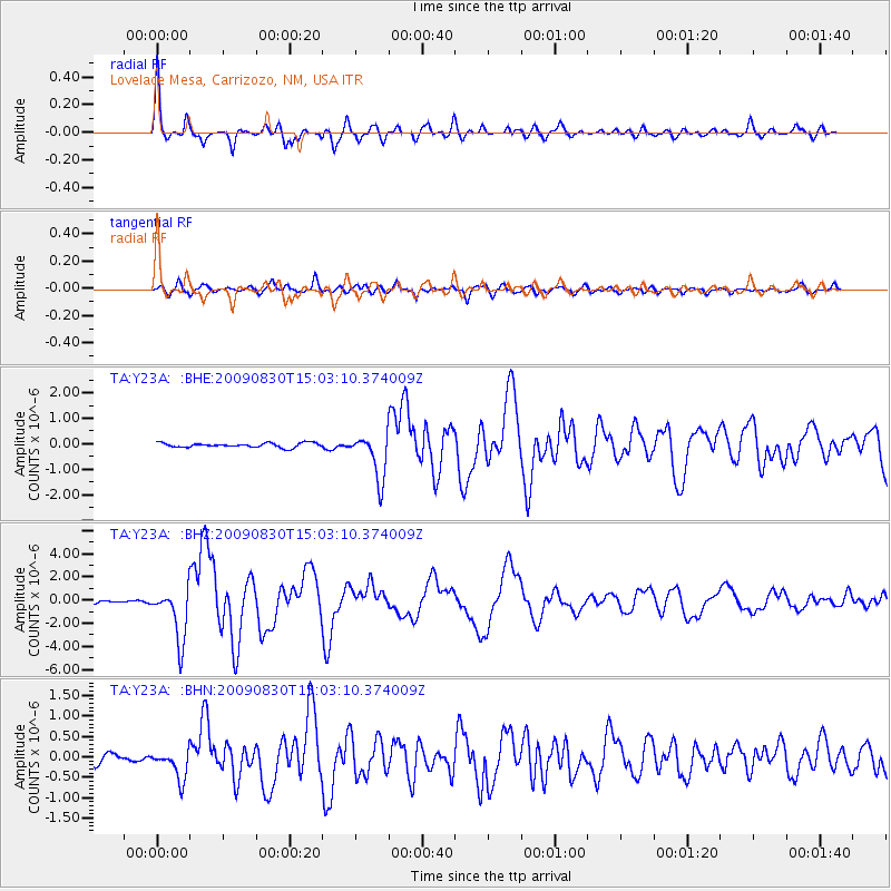
Y23A Lovelace Mesa, Carrizozo, NM, USA - Earthquake Result Viewer

| Earthquake location: |
Samoa Islands Region |
| Earthquake latitude/longitude: |
-15.2/-172.6 |
| Earthquake time(UTC): |
2009/08/30 (242) 14:51:32 GMT |
| Earthquake Depth: |
11 km |
| Earthquake Magnitude: |
6.4 MB, 6.3 MS, 6.6 MW, 6.6 MW |
| Earthquake Catalog/Contributor: |
WHDF/NEIC |
|
| Network: |
TA USArray Transportable Network (new EarthScope stations) |
| Station: |
Y23A Lovelace Mesa, Carrizozo, NM, USA |
| Lat/Lon: |
33.93 N/106.05 W |
| Elevation: |
1789 m |
|
| Distance: |
79.9 deg |
| Az: |
50.76 deg |
| Baz: |
244.06 deg |
| Ray Param: |
0.04862227 |
| Estimated Moho Depth: |
41.0 km |
| Estimated Crust Vp/Vs: |
1.71 |
| Assumed Crust Vp: |
6.502 km/s |
| Estimated Crust Vs: |
3.808 km/s |
| Estimated Crust Poisson's Ratio: |
0.24 |
|
| Radial Match: |
96.013916 % |
| Radial Bump: |
400 |
| Transverse Match: |
84.618965 % |
| Transverse Bump: |
400 |
| SOD ConfigId: |
2622 |
| Insert Time: |
2010-03-06 02:27:56.000 +0000 |
| GWidth: |
2.5 |
| Max Bumps: |
400 |
| Tol: |
0.001 |
|
Signal To Noise
| Channel | StoN | STA | LTA |
| TA:Y23A: :BHZ:20090830T15:03:10.374009Z | 17.895018 | 2.2888535E-6 | 1.2790451E-7 |
| TA:Y23A: :BHN:20090830T15:03:10.374009Z | 3.3528988 | 3.5593905E-7 | 1.061586E-7 |
| TA:Y23A: :BHE:20090830T15:03:10.374009Z | 10.540427 | 9.043284E-7 | 8.579618E-8 |
| Arrivals |
| Ps | 4.6 SECOND |
| PpPs | 17 SECOND |
| PsPs/PpSs | 21 SECOND |


