You are here: Home > Network List > BK - Berkeley Digital Seismograph Network Stations List
> Station HUMO Hull Mountain, OR > Earthquake Result Viewer
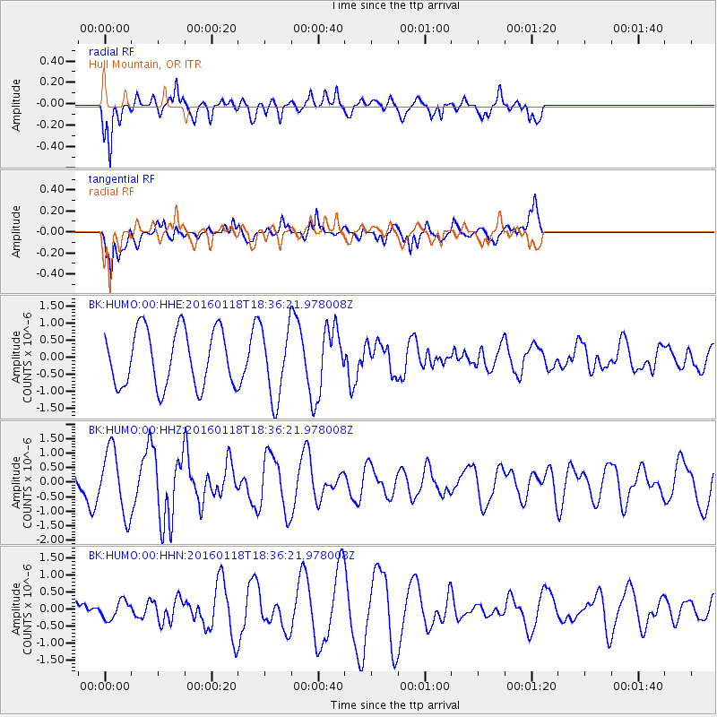
HUMO Hull Mountain, OR - Earthquake Result Viewer
*The percent match for this event was below the threshold and hence no stack was calculated.
| Earthquake location: |
South Of Fiji Islands |
| Earthquake latitude/longitude: |
-21.5/176.2 |
| Earthquake time(UTC): |
2016/01/18 (018) 18:24:17 GMT |
| Earthquake Depth: |
4.7 km |
| Earthquake Magnitude: |
5.8 MWW, 5.8 MWB, 5.9 MWC |
| Earthquake Catalog/Contributor: |
NEIC PDE/NEIC COMCAT |
|
| Network: |
BK Berkeley Digital Seismograph Network |
| Station: |
HUMO Hull Mountain, OR |
| Lat/Lon: |
42.61 N/122.96 W |
| Elevation: |
555 m |
|
| Distance: |
84.9 deg |
| Az: |
40.353 deg |
| Baz: |
234.783 deg |
| Ray Param: |
$rayparam |
*The percent match for this event was below the threshold and hence was not used in the summary stack. |
|
| Radial Match: |
64.10399 % |
| Radial Bump: |
338 |
| Transverse Match: |
75.93688 % |
| Transverse Bump: |
400 |
| SOD ConfigId: |
1399611 |
| Insert Time: |
2016-02-01 18:44:17.553 +0000 |
| GWidth: |
2.5 |
| Max Bumps: |
400 |
| Tol: |
0.001 |
|
Signal To Noise
| Channel | StoN | STA | LTA |
| BK:HUMO:00:HHZ:20160118T18:36:21.978008Z | 2.0729675 | 1.1142379E-6 | 5.375086E-7 |
| BK:HUMO:00:HHN:20160118T18:36:21.978008Z | 0.6019893 | 2.6598462E-7 | 4.4184276E-7 |
| BK:HUMO:00:HHE:20160118T18:36:21.978008Z | 1.2669226 | 1.0333671E-6 | 8.1565133E-7 |
| Arrivals |
| Ps | |
| PpPs | |
| PsPs/PpSs | |


