You are here: Home > Network List > TA - USArray Transportable Network (new EarthScope stations) Stations List
> Station BGNE Belgrade, NE, USA > Earthquake Result Viewer
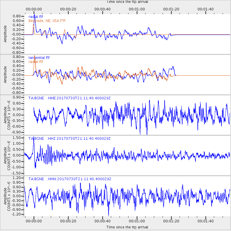
BGNE Belgrade, NE, USA - Earthquake Result Viewer
*The percent match for this event was below the threshold and hence no stack was calculated.
| Earthquake location: |
Kuril Islands |
| Earthquake latitude/longitude: |
46.2/151.0 |
| Earthquake time(UTC): |
2017/07/30 (211) 21:00:49 GMT |
| Earthquake Depth: |
87 km |
| Earthquake Magnitude: |
5.7 mb |
| Earthquake Catalog/Contributor: |
NEIC PDE/us |
|
| Network: |
TA USArray Transportable Network (new EarthScope stations) |
| Station: |
BGNE Belgrade, NE, USA |
| Lat/Lon: |
41.41 N/98.15 W |
| Elevation: |
573 m |
|
| Distance: |
73.3 deg |
| Az: |
47.205 deg |
| Baz: |
317.358 deg |
| Ray Param: |
$rayparam |
*The percent match for this event was below the threshold and hence was not used in the summary stack. |
|
| Radial Match: |
40.447227 % |
| Radial Bump: |
400 |
| Transverse Match: |
53.009678 % |
| Transverse Bump: |
400 |
| SOD ConfigId: |
13570011 |
| Insert Time: |
2019-04-28 12:28:45.960 +0000 |
| GWidth: |
2.5 |
| Max Bumps: |
400 |
| Tol: |
0.001 |
|
Signal To Noise
| Channel | StoN | STA | LTA |
| TA:BGNE: :HHZ:20170730T21:11:40.400029Z | 4.345706 | 5.906841E-7 | 1.3592363E-7 |
| TA:BGNE: :HHN:20170730T21:11:40.400029Z | 1.0620339 | 3.3038302E-7 | 3.110852E-7 |
| TA:BGNE: :HHE:20170730T21:11:40.400029Z | 1.3644139 | 2.958627E-7 | 2.1684234E-7 |
| Arrivals |
| Ps | |
| PpPs | |
| PsPs/PpSs | |


