You are here: Home > Network List > TA - USArray Transportable Network (new EarthScope stations) Stations List
> Station H24K Noodor Dome, AK, USA > Earthquake Result Viewer
H24K Noodor Dome, AK, USA - Earthquake Result Viewer
| Earthquake location: |
Kuril Islands |
| Earthquake latitude/longitude: |
46.2/151.0 |
| Earthquake time(UTC): |
2017/07/30 (211) 21:00:49 GMT |
| Earthquake Depth: |
87 km |
| Earthquake Magnitude: |
5.7 mb |
| Earthquake Catalog/Contributor: |
NEIC PDE/us |
|
| Network: |
TA USArray Transportable Network (new EarthScope stations) |
| Station: |
H24K Noodor Dome, AK, USA |
| Lat/Lon: |
65.84 N/147.88 W |
| Elevation: |
814 m |
|
| Distance: |
37.5 deg |
| Az: |
36.348 deg |
| Baz: |
269.152 deg |
| Ray Param: |
0.07583609 |
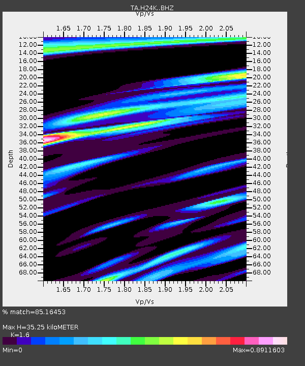
| Estimated Moho Depth: |
35.25 km |
| Estimated Crust Vp/Vs: |
1.60 |
| Assumed Crust Vp: |
6.566 km/s |
| Estimated Crust Vs: |
4.104 km/s |
| Estimated Crust Poisson's Ratio: |
0.18 |
|
| Radial Match: |
85.16453 % |
| Radial Bump: |
332 |
| Transverse Match: |
66.15984 % |
| Transverse Bump: |
400 |
| SOD ConfigId: |
13570011 |
| Insert Time: |
2019-04-28 12:29:28.030 +0000 |
| GWidth: |
2.5 |
| Max Bumps: |
400 |
| Tol: |
0.001 |
|
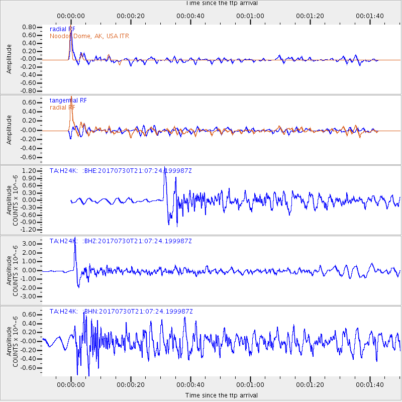
Signal To Noise
| Channel | StoN | STA | LTA |
| TA:H24K: :BHZ:20170730T21:07:24.199987Z | 12.159589 | 1.1116156E-6 | 9.141885E-8 |
| TA:H24K: :BHN:20170730T21:07:24.199987Z | 5.939318 | 2.769948E-7 | 4.6637474E-8 |
| TA:H24K: :BHE:20170730T21:07:24.199987Z | 8.345116 | 5.774478E-7 | 6.9195906E-8 |
| Arrivals |
| Ps | 3.5 SECOND |
| PpPs | 13 SECOND |
| PsPs/PpSs | 16 SECOND |


