You are here: Home > Network List > TA - USArray Transportable Network (new EarthScope stations) Stations List
> Station K29M Barlow Dome, YT, CAN > Earthquake Result Viewer
K29M Barlow Dome, YT, CAN - Earthquake Result Viewer
| Earthquake location: |
Kuril Islands |
| Earthquake latitude/longitude: |
46.2/151.0 |
| Earthquake time(UTC): |
2017/07/30 (211) 21:00:49 GMT |
| Earthquake Depth: |
87 km |
| Earthquake Magnitude: |
5.7 mb |
| Earthquake Catalog/Contributor: |
NEIC PDE/us |
|
| Network: |
TA USArray Transportable Network (new EarthScope stations) |
| Station: |
K29M Barlow Dome, YT, CAN |
| Lat/Lon: |
63.84 N/137.52 W |
| Elevation: |
1367 m |
|
| Distance: |
42.1 deg |
| Az: |
38.875 deg |
| Baz: |
280.466 deg |
| Ray Param: |
0.0731312 |
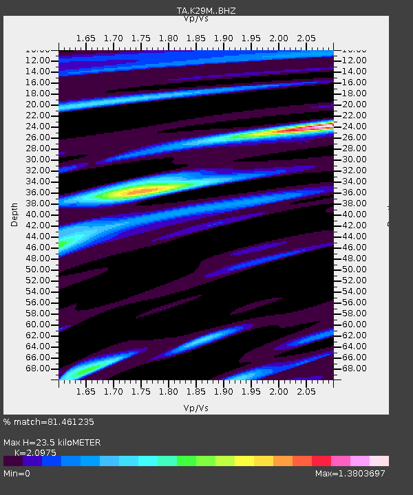
| Estimated Moho Depth: |
23.5 km |
| Estimated Crust Vp/Vs: |
2.10 |
| Assumed Crust Vp: |
6.566 km/s |
| Estimated Crust Vs: |
3.13 km/s |
| Estimated Crust Poisson's Ratio: |
0.35 |
|
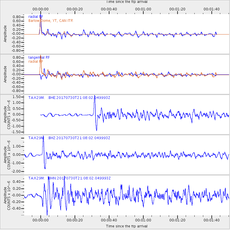
| Radial Match: |
81.461235 % |
| Radial Bump: |
329 |
| Transverse Match: |
74.55909 % |
| Transverse Bump: |
400 |
| SOD ConfigId: |
13570011 |
| Insert Time: |
2019-04-28 12:29:45.650 +0000 |
| GWidth: |
2.5 |
| Max Bumps: |
400 |
| Tol: |
0.001 |
|
Signal To Noise
| Channel | StoN | STA | LTA |
| TA:K29M: :BHZ:20170730T21:08:02.049993Z | 8.156339 | 9.026283E-7 | 1.10665866E-7 |
| TA:K29M: :BHN:20170730T21:08:02.049993Z | 3.1395738 | 2.6587995E-7 | 8.468663E-8 |
| TA:K29M: :BHE:20170730T21:08:02.049993Z | 9.909304 | 6.792756E-7 | 6.854928E-8 |
| Arrivals |
| Ps | 4.2 SECOND |
| PpPs | 10 SECOND |
| PsPs/PpSs | 15 SECOND |


