You are here: Home > Network List > US - United States National Seismic Network Stations List
> Station WMOK Wichita Mountains, Oklahoma, USA > Earthquake Result Viewer
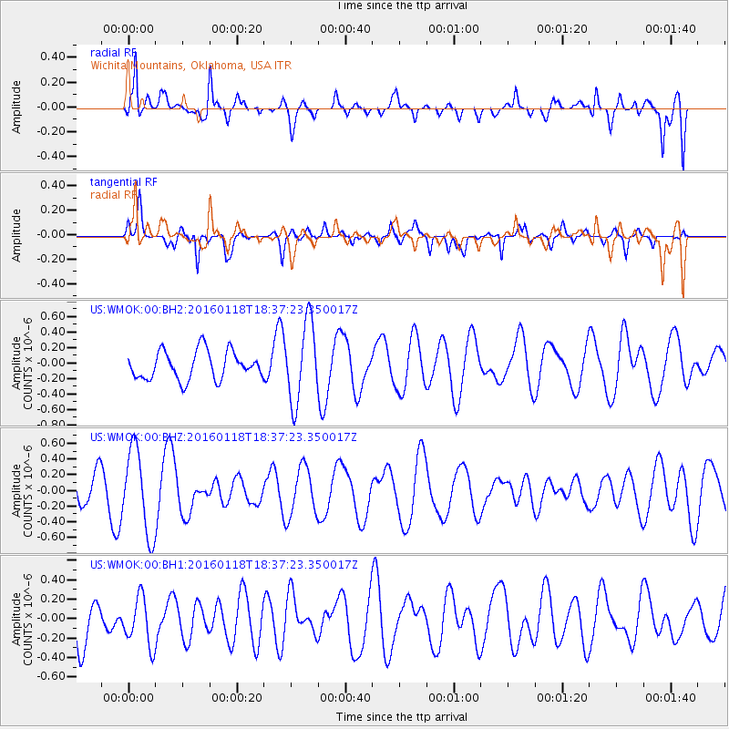
WMOK Wichita Mountains, Oklahoma, USA - Earthquake Result Viewer
*The percent match for this event was below the threshold and hence no stack was calculated.
| Earthquake location: |
South Of Fiji Islands |
| Earthquake latitude/longitude: |
-21.5/176.2 |
| Earthquake time(UTC): |
2016/01/18 (018) 18:24:17 GMT |
| Earthquake Depth: |
4.7 km |
| Earthquake Magnitude: |
5.8 MWW, 5.8 MWB, 5.9 MWC |
| Earthquake Catalog/Contributor: |
NEIC PDE/NEIC COMCAT |
|
| Network: |
US United States National Seismic Network |
| Station: |
WMOK Wichita Mountains, Oklahoma, USA |
| Lat/Lon: |
34.74 N/98.78 W |
| Elevation: |
486 m |
|
| Distance: |
98.1 deg |
| Az: |
55.96 deg |
| Baz: |
249.599 deg |
| Ray Param: |
$rayparam |
*The percent match for this event was below the threshold and hence was not used in the summary stack. |
|
| Radial Match: |
63.656467 % |
| Radial Bump: |
400 |
| Transverse Match: |
54.825153 % |
| Transverse Bump: |
310 |
| SOD ConfigId: |
1399611 |
| Insert Time: |
2016-02-01 18:48:49.394 +0000 |
| GWidth: |
2.5 |
| Max Bumps: |
400 |
| Tol: |
0.001 |
|
Signal To Noise
| Channel | StoN | STA | LTA |
| US:WMOK:00:BHZ:20160118T18:37:23.350017Z | 1.4181973 | 5.4319645E-7 | 3.8301894E-7 |
| US:WMOK:00:BH1:20160118T18:37:23.350017Z | 0.9960779 | 2.5957223E-7 | 2.605943E-7 |
| US:WMOK:00:BH2:20160118T18:37:23.350017Z | 2.8361187 | 5.1596857E-7 | 1.8192772E-7 |
| Arrivals |
| Ps | |
| PpPs | |
| PsPs/PpSs | |


