You are here: Home > Network List > TA - USArray Transportable Network (new EarthScope stations) Stations List
> Station M16K Timber Creek, AK, USA > Earthquake Result Viewer
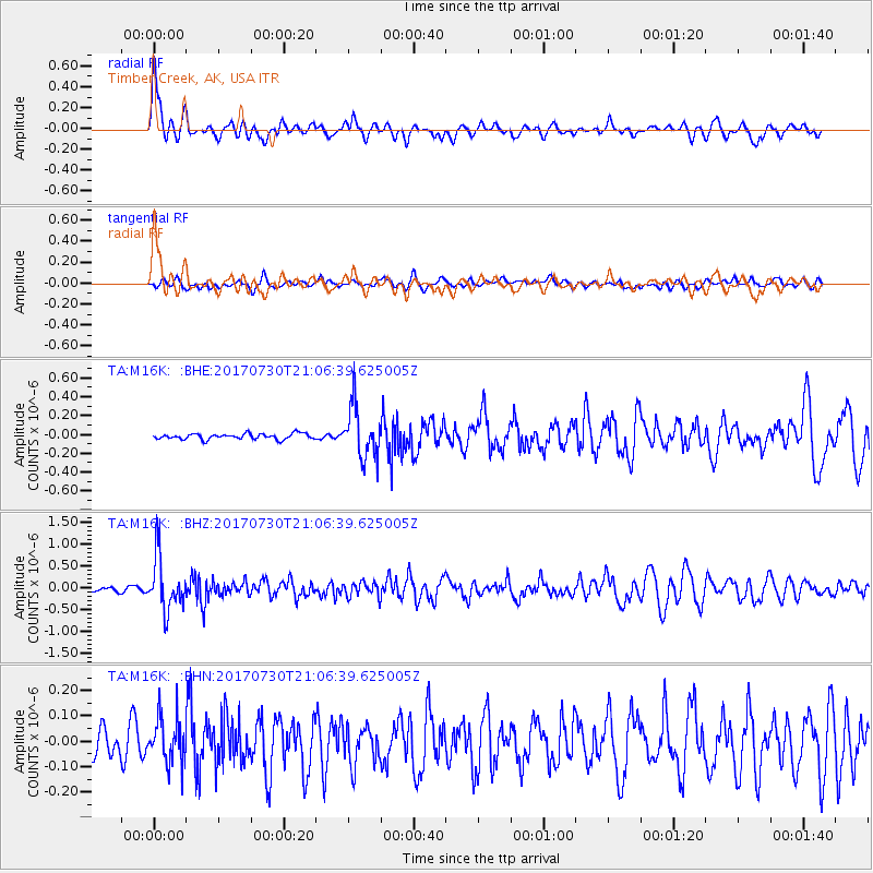
M16K Timber Creek, AK, USA - Earthquake Result Viewer
*The percent match for this event was below the threshold and hence no stack was calculated.
| Earthquake location: |
Kuril Islands |
| Earthquake latitude/longitude: |
46.2/151.0 |
| Earthquake time(UTC): |
2017/07/30 (211) 21:00:49 GMT |
| Earthquake Depth: |
87 km |
| Earthquake Magnitude: |
5.7 mb |
| Earthquake Catalog/Contributor: |
NEIC PDE/us |
|
| Network: |
TA USArray Transportable Network (new EarthScope stations) |
| Station: |
M16K Timber Creek, AK, USA |
| Lat/Lon: |
61.02 N/158.96 W |
| Elevation: |
394 m |
|
| Distance: |
32.3 deg |
| Az: |
44.378 deg |
| Baz: |
265.837 deg |
| Ray Param: |
$rayparam |
*The percent match for this event was below the threshold and hence was not used in the summary stack. |
|
| Radial Match: |
78.89005 % |
| Radial Bump: |
400 |
| Transverse Match: |
52.6578 % |
| Transverse Bump: |
400 |
| SOD ConfigId: |
13570011 |
| Insert Time: |
2019-04-28 12:29:57.226 +0000 |
| GWidth: |
2.5 |
| Max Bumps: |
400 |
| Tol: |
0.001 |
|
Signal To Noise
| Channel | StoN | STA | LTA |
| TA:M16K: :BHZ:20170730T21:06:39.625005Z | 15.132581 | 5.991469E-7 | 3.959318E-8 |
| TA:M16K: :BHN:20170730T21:06:39.625005Z | 1.350664 | 8.9595275E-8 | 6.6334245E-8 |
| TA:M16K: :BHE:20170730T21:06:39.625005Z | 8.92005 | 2.6818785E-7 | 3.0065735E-8 |
| Arrivals |
| Ps | |
| PpPs | |
| PsPs/PpSs | |


