You are here: Home > Network List > TA - USArray Transportable Network (new EarthScope stations) Stations List
> Station M31M Drury Creek, Yukon, CA > Earthquake Result Viewer
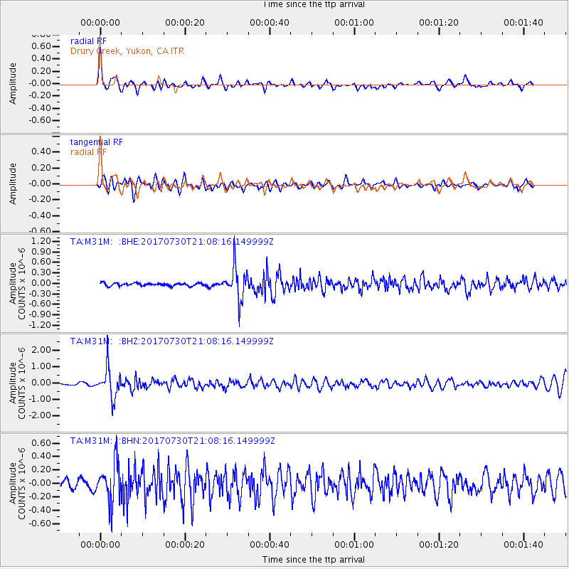
M31M Drury Creek, Yukon, CA - Earthquake Result Viewer
*The percent match for this event was below the threshold and hence no stack was calculated.
| Earthquake location: |
Kuril Islands |
| Earthquake latitude/longitude: |
46.2/151.0 |
| Earthquake time(UTC): |
2017/07/30 (211) 21:00:49 GMT |
| Earthquake Depth: |
87 km |
| Earthquake Magnitude: |
5.7 mb |
| Earthquake Catalog/Contributor: |
NEIC PDE/us |
|
| Network: |
TA USArray Transportable Network (new EarthScope stations) |
| Station: |
M31M Drury Creek, Yukon, CA |
| Lat/Lon: |
62.20 N/134.39 W |
| Elevation: |
639 m |
|
| Distance: |
43.8 deg |
| Az: |
40.78 deg |
| Baz: |
284.647 deg |
| Ray Param: |
$rayparam |
*The percent match for this event was below the threshold and hence was not used in the summary stack. |
|
| Radial Match: |
76.3028 % |
| Radial Bump: |
400 |
| Transverse Match: |
69.53656 % |
| Transverse Bump: |
400 |
| SOD ConfigId: |
13570011 |
| Insert Time: |
2019-04-28 12:30:06.718 +0000 |
| GWidth: |
2.5 |
| Max Bumps: |
400 |
| Tol: |
0.001 |
|
Signal To Noise
| Channel | StoN | STA | LTA |
| TA:M31M: :BHZ:20170730T21:08:16.149999Z | 9.602956 | 9.0744936E-7 | 9.449688E-8 |
| TA:M31M: :BHN:20170730T21:08:16.149999Z | 4.044227 | 2.9698523E-7 | 7.343436E-8 |
| TA:M31M: :BHE:20170730T21:08:16.149999Z | 12.319457 | 4.6637066E-7 | 3.785643E-8 |
| Arrivals |
| Ps | |
| PpPs | |
| PsPs/PpSs | |


