You are here: Home > Network List > TA - USArray Transportable Network (new EarthScope stations) Stations List
> Station R32K Eaglecrest, AK, USA > Earthquake Result Viewer
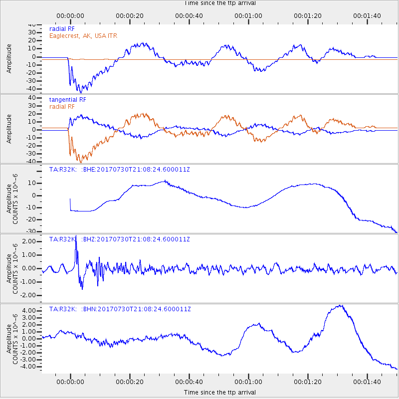
R32K Eaglecrest, AK, USA - Earthquake Result Viewer
*The percent match for this event was below the threshold and hence no stack was calculated.
| Earthquake location: |
Kuril Islands |
| Earthquake latitude/longitude: |
46.2/151.0 |
| Earthquake time(UTC): |
2017/07/30 (211) 21:00:49 GMT |
| Earthquake Depth: |
87 km |
| Earthquake Magnitude: |
5.7 mb |
| Earthquake Catalog/Contributor: |
NEIC PDE/us |
|
| Network: |
TA USArray Transportable Network (new EarthScope stations) |
| Station: |
R32K Eaglecrest, AK, USA |
| Lat/Lon: |
58.27 N/134.52 W |
| Elevation: |
386 m |
|
| Distance: |
44.9 deg |
| Az: |
46.213 deg |
| Baz: |
288.424 deg |
| Ray Param: |
$rayparam |
*The percent match for this event was below the threshold and hence was not used in the summary stack. |
|
| Radial Match: |
46.032784 % |
| Radial Bump: |
400 |
| Transverse Match: |
49.9524 % |
| Transverse Bump: |
400 |
| SOD ConfigId: |
13570011 |
| Insert Time: |
2019-04-28 12:30:42.827 +0000 |
| GWidth: |
2.5 |
| Max Bumps: |
400 |
| Tol: |
0.001 |
|
Signal To Noise
| Channel | StoN | STA | LTA |
| TA:R32K: :BHZ:20170730T21:08:24.600011Z | 7.0971737 | 8.622307E-7 | 1.2148931E-7 |
| TA:R32K: :BHN:20170730T21:08:24.600011Z | 1.6121086 | 1.3244235E-6 | 8.215473E-7 |
| TA:R32K: :BHE:20170730T21:08:24.600011Z | 1.8617709 | 1.482053E-5 | 7.960448E-6 |
| Arrivals |
| Ps | |
| PpPs | |
| PsPs/PpSs | |


