You are here: Home > Network List > UW - Pacific Northwest Regional Seismic Network Stations List
> Station LEBA Lebam, WA, USA > Earthquake Result Viewer
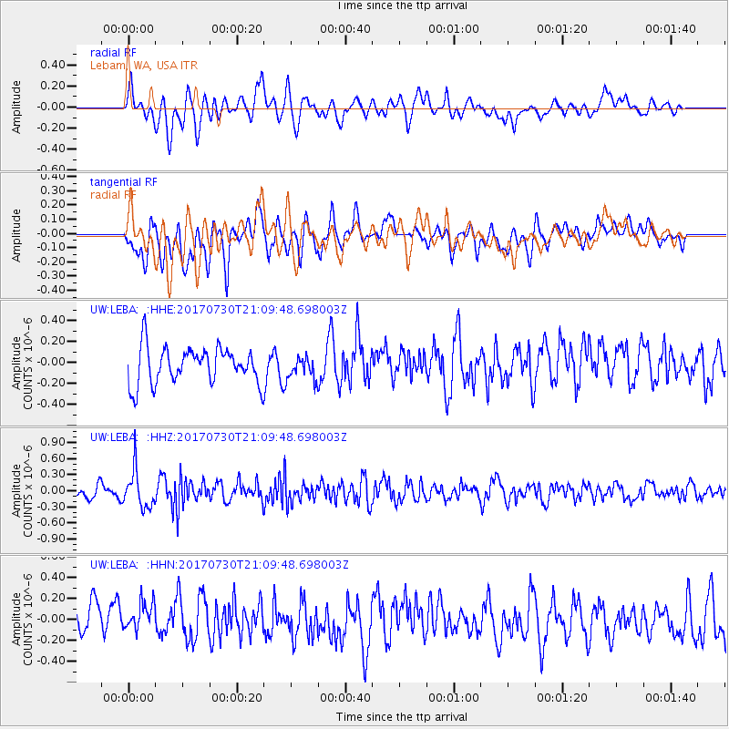
LEBA Lebam, WA, USA - Earthquake Result Viewer
*The percent match for this event was below the threshold and hence no stack was calculated.
| Earthquake location: |
Kuril Islands |
| Earthquake latitude/longitude: |
46.2/151.0 |
| Earthquake time(UTC): |
2017/07/30 (211) 21:00:49 GMT |
| Earthquake Depth: |
87 km |
| Earthquake Magnitude: |
5.7 mb |
| Earthquake Catalog/Contributor: |
NEIC PDE/us |
|
| Network: |
UW Pacific Northwest Regional Seismic Network |
| Station: |
LEBA Lebam, WA, USA |
| Lat/Lon: |
46.55 N/123.56 W |
| Elevation: |
73 m |
|
| Distance: |
56.1 deg |
| Az: |
56.041 deg |
| Baz: |
303.435 deg |
| Ray Param: |
$rayparam |
*The percent match for this event was below the threshold and hence was not used in the summary stack. |
|
| Radial Match: |
52.308228 % |
| Radial Bump: |
400 |
| Transverse Match: |
64.799065 % |
| Transverse Bump: |
400 |
| SOD ConfigId: |
13570011 |
| Insert Time: |
2019-04-28 12:31:43.032 +0000 |
| GWidth: |
2.5 |
| Max Bumps: |
400 |
| Tol: |
0.001 |
|
Signal To Noise
| Channel | StoN | STA | LTA |
| UW:LEBA: :HHZ:20170730T21:09:48.698003Z | 3.8433056 | 3.5190993E-7 | 9.156439E-8 |
| UW:LEBA: :HHN:20170730T21:09:48.698003Z | 1.2925886 | 1.6090073E-7 | 1.2447947E-7 |
| UW:LEBA: :HHE:20170730T21:09:48.698003Z | 0.5970254 | 1.03185855E-7 | 1.7283328E-7 |
| Arrivals |
| Ps | |
| PpPs | |
| PsPs/PpSs | |


