You are here: Home > Network List > TA - USArray Transportable Network (new EarthScope stations) Stations List
> Station T24A Torres, Weston, CO, USA > Earthquake Result Viewer
T24A Torres, Weston, CO, USA - Earthquake Result Viewer
| Earthquake location: |
Kuril Islands |
| Earthquake latitude/longitude: |
46.0/151.5 |
| Earthquake time(UTC): |
2009/04/07 (097) 04:23:33 GMT |
| Earthquake Depth: |
31 km |
| Earthquake Magnitude: |
6.5 MB, 6.8 MS, 6.9 MW, 6.9 MW |
| Earthquake Catalog/Contributor: |
WHDF/NEIC |
|
| Network: |
TA USArray Transportable Network (new EarthScope stations) |
| Station: |
T24A Torres, Weston, CO, USA |
| Lat/Lon: |
37.07 N/105.05 W |
| Elevation: |
2510 m |
|
| Distance: |
72.4 deg |
| Az: |
54.691 deg |
| Baz: |
314.716 deg |
| Ray Param: |
0.053613294 |
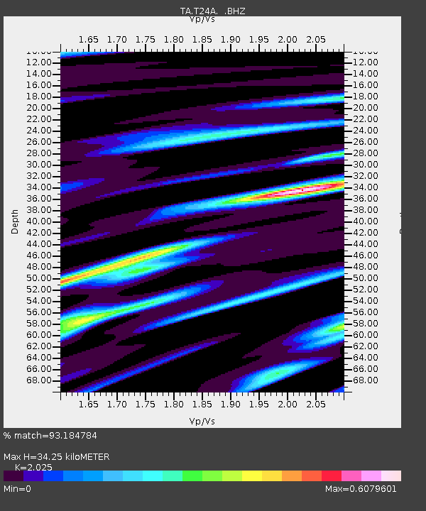
| Estimated Moho Depth: |
34.25 km |
| Estimated Crust Vp/Vs: |
2.03 |
| Assumed Crust Vp: |
6.316 km/s |
| Estimated Crust Vs: |
3.119 km/s |
| Estimated Crust Poisson's Ratio: |
0.34 |
|
| Radial Match: |
93.184784 % |
| Radial Bump: |
387 |
| Transverse Match: |
87.02991 % |
| Transverse Bump: |
400 |
| SOD ConfigId: |
2658 |
| Insert Time: |
2010-03-06 02:30:03.181 +0000 |
| GWidth: |
2.5 |
| Max Bumps: |
400 |
| Tol: |
0.001 |
|

Signal To Noise
| Channel | StoN | STA | LTA |
| TA:T24A: :BHZ:20090407T04:34:25.498999Z | 27.0683 | 4.525065E-6 | 1.6717212E-7 |
| TA:T24A: :BHN:20090407T04:34:25.498999Z | 6.8217125 | 1.5121042E-6 | 2.2166049E-7 |
| TA:T24A: :BHE:20090407T04:34:25.498999Z | 6.1796103 | 1.1910786E-6 | 1.9274333E-7 |
| Arrivals |
| Ps | 5.7 SECOND |
| PpPs | 16 SECOND |
| PsPs/PpSs | 22 SECOND |


